 Filter: Categories of Wisconsin Historical Images
Filter: Subject of Fields (Agriculture)
Filter: Community of Madison
Filter: Categories of Wisconsin Historical Images
Filter: Subject of Fields (Agriculture)
Filter: Community of Madison
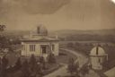
| Date: | 1880 |
|---|---|
| Description: | Elevated view of the University of Wisconsin-Madison Washburn Observatory. Hill, trees and fields are in the background. A man is standing near a small obs... |

| Date: | 09 10 1875 |
|---|---|
| Description: | View looking west across the area once occupied by Camp Randall during the Civil War and towards the Breese Stevens farm property. The Madison Centennial ... |
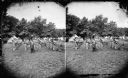
| Date: | 1876 |
|---|---|
| Description: | Quite possibly this is the "View of the Grand Music Band" listed in the "Centennial Views of the City of Madison, July 4th, 1876. Views of Chicago Light Gu... |

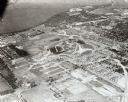
| Date: | 1956 |
|---|---|
| Description: | Aerial view of the new Madison television facility, WISC-TV (Channel 3), showing the transmitting tower in construction. The location is to the southwest,... |

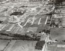
| Date: | 1956 |
|---|---|
| Description: | Aerial view, looking eastward from a point several miles outside the southwestern limits of Madison in the direction of Verona. Crossing the image diagonal... |

| Date: | 1930 |
|---|---|
| Description: | Aerial view above Shorewood Hills near Madison, looking northeast. |

| Date: | 03 24 1913 |
|---|---|
| Description: | Picnic Point from the University Farm fields, now known as Observatory Hill. |

| Date: | 1909 |
|---|---|
| Description: | View from Sunset Point in Owen Park, which is now a part of Hoyt Park. Lake Mendota is in the distance. |

| Date: | 1909 |
|---|---|
| Description: | View from the University of Wisconsin service building smokestack of south Madison, including Mills Street, Mound Street, and the Greenbush. Lake Monona is... |

| Date: | |
|---|---|
| Description: | An aerial view of both Picnic Point and Second Point looking toward the isthmus. Members of the Jackson Family had summer homes at Second Point at this tim... |
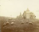
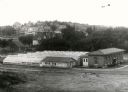
| Date: | 1900 |
|---|---|
| Description: | University of Wisconsin-Madison Agricultural campus with sheep and a dairy barn in the background. |
| Date: | 07 27 1944 |
|---|---|
| Description: | City of Madison staff demonstrating homemade liquid mosquito sprayer designed by Dr. Bernhard "Dommie" Domogalla, city biochemist. Left to right: LeRoy Joh... |

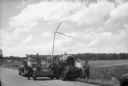
| Date: | 08 11 1944 |
|---|---|
| Description: | Six Russian representatives of the Soviet government observing a new McCormick-Deering Company Model 50-T hay baler at the Bowman Dairy Farm on Fish Hatche... |
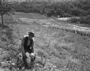
| Date: | 10 1946 |
|---|---|
| Description: | Man (Mr. Goodyear?) holding a muskmelon in an agricultural field. |
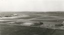
| Date: | 1955 |
|---|---|
| Description: | An aerial view at Truax Field showing the Municipal Airport Administration Building. |
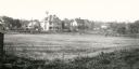
| Date: | 1902 |
|---|---|
| Description: | View across field towards two residences of University of Wisconsin Professors. At 1532 University Avenue is the Harry L. Russell home and at 1540 Universi... |
| Date: | 1913 |
|---|---|
| Description: | View looking southwest at the University Heights neighborhood from near the corner of University Avenue and Breese Terrace. In the foreground is the Univer... |
| Date: | 09 1958 |
|---|---|
| Description: | Aerial view of University Farms neighborhood near Lake Mendota. |
| Date: | 09 1958 |
|---|---|
| Description: | University Hill Farms from an aerial perspective. |
If you didn't find the material you searched for, our Library Reference Staff can help.
Call our reference desk at 608-264-6535 or email us at:
