Filter: Categories of Wisconsin Historical Images
Filter: Subject of Fields (Agriculture)
Filter: Community of Madison
Filter: Creator Name of Newhouse, John
Filter: Categories of Wisconsin Historical Images
Filter: Subject of Fields (Agriculture)
Filter: Community of Madison
Filter: Creator Name of Newhouse, John

| Date: | 1956 |
|---|---|
| Description: | Aerial view of the South Park Street interchange. |

| Date: | 1950 |
|---|---|
| Description: | Aerial view of the Frank Lloyd-Wright-dsigned Unitarian Church under construction and the Veteran's Administration Hospital, also under construction, to th... |
| Date: | |
|---|---|
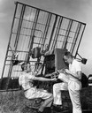
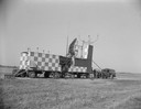
| Description: | Radar equipment at Truax Field, formerly Madison Municipal Airport. |

| Date: | 1956 |
|---|---|
| Description: | Aerial view of the new Madison television facility, WISC-TV (Channel 3), showing the transmitting tower in construction. The location is to the southwest,... |

| Date: | 1956 |
|---|---|
| Description: | Aerial view, looking eastward from a point several miles outside the southwestern limits of Madison in the direction of Verona. Crossing the image diagonal... |

| Date: | |
|---|---|
| Description: | An aerial view of Governor's Island. A cutout of an arrow has been added. |

| Date: | 1955 |
|---|---|
| Description: | Aerial view, looking west from over Hoyt Park toward Midvale Boulevard. |

| Date: | 1954 |
|---|---|
| Description: | Aerial view of the construction of Herbert Schenk Elementary School, as well as the surrounding neighborhood. |
If you didn't find the material you searched for, our Library Reference Staff can help.
Call our reference desk at 608-264-6535 or email us at: