Filter: Categories of Wisconsin Historical Images
Filter: Subject of Ferries
Filter: Year of 1900-1999
Filter: Year of 1960-1969
Filter: Categories of Wisconsin Historical Images
Filter: Subject of Ferries
Filter: Year of 1900-1999
Filter: Year of 1960-1969
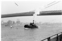
| Date: | 1969 |
|---|---|
| Description: | The Island's Edge, Williamsburg Bridge, East River. |

| Date: | 08 24 1964 |
|---|---|
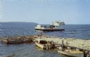
| Description: | View from shoreline of two ferry boats in Lake Michigan. These two boats were once used as Mackinac Straits ferry boats and were later used as potato packi... |

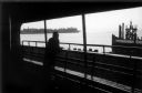
| Date: | 1968 |
|---|---|
| Description: | View of Manhattan from the Staten Island Ferry, with a couple standing in the foreground. The woman is wearing a leopard print coat, and seagulls wheel in ... |
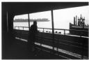
| Date: | 1968 |
|---|---|
| Description: | Two passengers stand over a bench and look out of the ferry towards the water. The developed shoreline and a pier with a seagull perched on top can be see... |
| Date: | 1963 |
|---|---|
| Description: | View from road of the ferry "Colsac II" arriving at the shoreline of the Wisconsin River, with an automobile on the right waiting to board. |

| Date: | 1961 |
|---|---|
| Description: | View from shoreline of a woman standing on a riverbank waving at the Merrimac ferry. |

| Date: | 1961 |
|---|---|
| Description: | The Merrimac Ferry is on the river with a pick-up truck aboard. A rowboat rests on a pier in the foreground. A man wearing a hat rests his foot on the rail... |

| Date: | 1966 |
|---|---|
| Description: | A colored map depiction of Door County, Wisconsin, with pictorial highlights, titled: "Door County — Wisconsin's Air Conditioned Peninsula Playground." |
| Date: | 1961 |
|---|---|
| Description: | Color postcard view of the "Voyageur," a car and passenger ferry operating between mainland Door County and Washington Island. Two motorboats are moored on... |
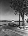
| Date: | 09 15 1960 |
|---|---|
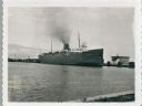
| Description: | View across water towards a carferry named "City of Flint," moored at a dock. There are buildings on the dock on the right. |

| Date: | 1960 |
|---|---|
| Description: | This colored road map shows roads in Wisconsin as well as portions of nearby states. Information on the quality and type of any road shown can be found in ... |

| Date: | 1962 |
|---|---|
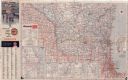
| Description: | This colored road map shows roads in Wisconsin as well as portions of nearby states. The map is organized such that a single map of Wisconsin is divided on... |
| Date: | 1962 |
|---|---|
| Description: | This colored road map shows roads in Wisconsin as well as portions of nearby states. The map is organized such that a single map of Wisconsin is divided on... |

| Date: | 1963 |
|---|---|
| Description: | This colored road map shows automobile roads in Wisconsin as well as portions of nearby states. The map is organized such that a single map of Wisconsin is... |
| Date: | 1963 |
|---|---|
| Description: | This colored road map shows automobile roads in Wisconsin as well as portions of nearby states. The map is organized such that a single map of Wisconsin is... |

| Date: | 1965 |
|---|---|
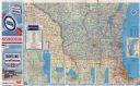
| Description: | This colored road map shows automobile roads in Wisconsin as well as portions of nearby states. Information on the quality and type of any road shown (inte... |
If you didn't find the material you searched for, our Library Reference Staff can help.
Call our reference desk at 608-264-6535 or email us at: