 Filter: Categories of Wisconsin Historical Images
Filter: Subject of Ferries
Filter: Year of 1900-1999
Filter: Subject of water
Filter: Year of 1940-1949
Filter: Categories of Wisconsin Historical Images
Filter: Subject of Ferries
Filter: Year of 1900-1999
Filter: Subject of water
Filter: Year of 1940-1949
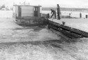
| Date: | 12 1948 |
|---|---|
| Description: | Two men docking a ferry boat at La Pointe in December. Ferry service closed two days after this photograph was taken. |
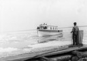
| Date: | 04 10 1948 |
|---|---|
| Description: | Man standing on dock watching the ferry "Gar-How" coming to dock on the first trip in spring. |
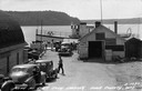
| Date: | 09 1947 |
|---|---|
| Description: | Slightly elevated view of people waiting for the ferry at the Gill's Rock landing in Door County. Caption reads: "Scene at Gill's Rock Landing, Door County... |
| Date: | 1940 |
|---|---|
| Description: | Colsac Ferry across the Wisconsin River at Merrimac. There is a bridge across the river in the background on the left. |

| Date: | 1944 |
|---|---|
| Description: | This nine-part map from the U.S. Bureau of Public Roads identifies federal and state highways in Wisconsin by pavement type. County, forest, park, and publ... |
| Date: | 07 22 1941 |
|---|---|
| Description: | Scrapbook page of trip highlights from a bike hosteling trip to Pine Bluff (Dane County), Sauk City (Sauk County), and Okee (Columbia County), sponsored by... |

| Date: | 1940 |
|---|---|
| Description: | This tourist map of Door County, Wisconsin, lists the points of interest and tourist hotels, cabins and cottages in the area. Ferry schedules to Washington... |

| Date: | 1946 |
|---|---|
| Description: | This colored road map shows automobile roads in Wisconsin as well as portions of nearby states. Information on the quality and type of any road shown (Inte... |

| Date: | 1948 |
|---|---|
| Description: | This colored road map shows automobile roads in Wisconsin as well as portions of nearby states.Information on the quality and type of any road shown (bitum... |

| Date: | 1948 |
|---|---|
| Description: | This colored road map shows automobile roads in Wisconsin as well as portions of nearby states. The map is organized such that a single map of Wisconsin is... |
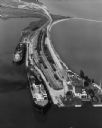
| Date: | 09 17 1948 |
|---|---|
| Description: | Aerial view of two Lake Michigan ferries tied up at harbor slips. The eastern terminus of the Green Bay Route was the Lake Michigan port city of Kewaunee. ... |
If you didn't find the material you searched for, our Library Reference Staff can help.
Call our reference desk at 608-264-6535 or email us at: