Filter: Categories of Wisconsin Historical Images
Filter: Subject of Ferries
Filter: Year of 1900-1999
Filter: Subject of human settlements
Filter: Categories of Wisconsin Historical Images
Filter: Subject of Ferries
Filter: Year of 1900-1999
Filter: Subject of human settlements

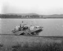
| Date: | 1929 |
|---|---|
| Description: | Ferryboat landing, with the boats providing service between Gills Rock and Washington Island. |
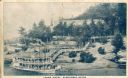
| Date: | 1910 |
|---|---|
| Description: | Elevated view across water toward the Larks Hotel and ferry. Caption reads: "Larks Hotel, Wisconsin Dells." |
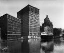
| Date: | 07 13 1915 |
|---|---|
| Description: | Looking south from Wells Street. A boat travels along the Milwaukee River in the foreground. Landmarks left to right: Manufacturers Home Building, First Na... |
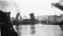
| Date: | 06 1939 |
|---|---|
| Description: | Bridge on the Manitowoc River raised to allow the Pere Marquette car ferry through. River dredging equipment can be seen in the foreground. |

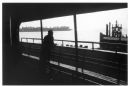
| Date: | 1968 |
|---|---|
| Description: | View of Manhattan from the Staten Island Ferry, with a couple standing in the foreground. The woman is wearing a leopard print coat, and seagulls wheel in ... |
| Date: | 1921 |
|---|---|
| Description: | View from shoreline looking down at three men posing on a paddle steamer ferry boat carrying an automobile. The boat has the words "Cassville" and "Dewey" ... |
| Date: | 1910 |
|---|---|
| Description: | View along shoreline of man examining a rowboat while crouching in the water wearing boots. Behind him is a ferry. There are several men on the shore watch... |

| Date: | 1944 |
|---|---|
| Description: | This nine-part map from the U.S. Bureau of Public Roads identifies federal and state highways in Wisconsin by pavement type. County, forest, park, and publ... |

| Date: | 1950 |
|---|---|
| Description: | This road map shows federal, state and county roads in Wisconsin, northern Illinois, northeastern Iowa, eastern Minnesota, and the western portion of Michi... |

| Date: | 1911 |
|---|---|
| Description: | This map of Duluth and Superior shows street car routes, railroads, ferries, some points of interest, and lighthouses. The bottom left of the map reads: "C... |

| Date: | 1966 |
|---|---|
| Description: | A colored map depiction of Door County, Wisconsin, with pictorial highlights, titled: "Door County — Wisconsin's Air Conditioned Peninsula Playground." |

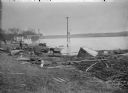
| Date: | 12 17 1957 |
|---|---|
| Description: | Carferry slip with pilings in the foreground, and a shoreline in the background. The pier is made of timbers. In the background on the left is a factory wi... |

| Date: | 1923 |
|---|---|
| Description: | This map shows portions of Minnesota, Iowa, Wisconsin, Illinois, Indiana, Ohio, Michigan, New York, Vermont, Massachusetts, Connecticut, Ontario, and Quebe... |

| Date: | 1900 |
|---|---|
| Description: | This map shows the boundary lines between ceded and unceded land in compliance with the Treaty of Prairie du Chen of 1829. It also shows roads, rivers, por... |

| Date: | 1933 |
|---|---|
| Description: | This map shows the major highways and freeways of Wisconsin as well as road surfaces, state parks, points of interest, ferry routes, bridges, and towns whe... |

| Date: | 1936 |
|---|---|
| Description: | This map shows road surfaces, construction, flying fields, seaplane landings, populations of cities and towns, and ferry routes of Wisconsin and some of th... |

| Date: | 1930 |
|---|---|
| Description: | This map shows the entire state plus portions of Illinois, Iowa, Minnesota, and Michigan outlined in blue. The map shows roads, state parks (black triangle... |

| Date: | 1928 |
|---|---|
| Description: | This map shows the entire state of Wisconsin as well as portions of Michigan, Minnesota, Iowa and Illinois. Lake Michigan, Lake Superior, Lake Winnebago a... |

| Date: | 1934 |
|---|---|
| Description: | This road map contains automobile routes for the state of Wisconsin as well as portions of Minnesota, Illinois, Iowa and Michigan. Lake Michigan, Lake Sup... |
If you didn't find the material you searched for, our Library Reference Staff can help.
Call our reference desk at 608-264-6535 or email us at: