 Filter: Categories of Wisconsin Historical Images
Filter: Subject of Farmhouses
Filter: Subject of lakes
Filter: Categories of Wisconsin Historical Images
Filter: Subject of Farmhouses
Filter: Subject of lakes
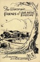
| Date: | 1948 |
|---|---|
| Description: | Cover for the 1948 Wisconsin Friends of Our Native Landscape program. Depicted is a sketch of a tree, a fence, and a small town by a lake. The Wisconsin Fr... |

| Date: | 1856 |
|---|---|
| Description: | The Ludemann's [also spelled Lueddemann] farm had been cultivated since the early 1850s by Mr. Ludemann, "a very pleasant Saxon with his very pleasant wife... |
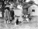
| Date: | 1917 |
|---|---|
| Description: | A group of people under a tree in a farmyard, with possibly a lake in the background. Two women, with heavy netting on their hats, hold luggage. A toddler ... |

| Date: | |
|---|---|
| Description: | Colorized postcard of the horseshoe curve of railroad tracks. Elevated view of the railroad tracks with train snaking past a farmhouse and a bridge suspend... |
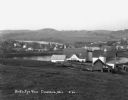
| Date: | 1930 |
|---|---|
| Description: | View from hill of a farm near a pond. There are homes along the far shoreline, and a lake and hills in the far background. |

| Date: | 1897 |
|---|---|
| Description: | This 1897 map of Sawyer County, Wisconsin, shows the township and range system, sections, roads, farm houses, camps, school houses, dams, bridges, Indian r... |

| Date: | 1902 |
|---|---|
| Description: | This 1902 map of the eastern portion of Sawyer County, Wisconsin, shows the township and range system, sections, roads, farm houses, camps, school houses, ... |

| Date: | 1919 |
|---|---|
| Description: | This 1919 map of Sawyer County, Wisconsin, shows the township and range system, sections, cities and villages, roads, railroads, farm houses, the Indian re... |

| Date: | 1927 |
|---|---|
| Description: | This Blue line print map shows trade area boundaries, lakes, farm homes, railways, high schools, public highways, and townships. A symbol key is included i... |

| Date: | 1900 |
|---|---|
| Description: | This map shows landownership, churches, schools, farm houses, wagon roads, railroads, and townships and includes businesses advertisements, tables of stati... |
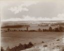
| Date: | 1892 |
|---|---|
| Description: | An elevated view of a gently rolling landscape with cows grazing in the middle distance. At right is a farmhouse and outbuildings. Young trees have been pl... |
If you didn't find the material you searched for, our Library Reference Staff can help.
Call our reference desk at 608-264-6535 or email us at: