Visit our other Wisconsin Historical Society websites!
 Filter: Categories of Wisconsin Historical Images
Filter: Subject of Farmhouses
Filter: Subject of education
Filter: Categories of Wisconsin Historical Images
Filter: Subject of Farmhouses
Filter: Subject of education
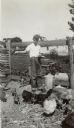
| Date: | 1933 |
|---|---|
| Description: | Frank Smith, Jr., age 12, feeds chickens on his father's farm. The farmhouse is in the background. Young Smith was a student at the Hillcrest School, Distr... |

| Date: | |
|---|---|
| Description: | You came to know that book by its covered distance, well remembered by the measure of the trudging barefoot mile |

| Date: | 1927 |
|---|---|
| Description: | This Blue line print map shows trade area boundaries, lakes, farm homes, railways, high schools, public highways, and townships. A symbol key is included i... |

| Date: | 1900 |
|---|---|
| Description: | This map shows landownership, churches, schools, farm houses, wagon roads, railroads, and townships and includes businesses advertisements, tables of stati... |

| Date: | 1912 |
|---|---|
| Description: | This map shows land for sale by the Rusk Farm Company. Caption reads, "Look carefully at the map. Notice the thickly settled country on all sides of our la... |
If you didn't find the material you searched for, our Library Reference Staff can help.
Call our reference desk at 608-264-6535 or email us at: