 Filter: Categories of Wisconsin Historical Images
Filter: Subject of Fairs
Filter: Subject of water
Filter: Categories of Wisconsin Historical Images
Filter: Subject of Fairs
Filter: Subject of water

| Date: | 1892 |
|---|---|
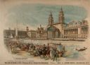
| Description: | Bird's-eye view of the Columbian Exposition pavilions from the vantage point of Lake Michigan. Included is an inset of the Union Passenger Station (now Uni... |
| Date: | 1893 |
|---|---|
| Description: | Advertising poster featuring color illustration of a crowd gathered around a Deering grain binder and mower at the Columbian Exposition in Chicago. |
| Date: | 01 09 1933 |
|---|---|
| Description: | Bird's eye view of International Harvester's exhibit building at the "A Century of Progress" world's fair in Chicago. The shore of Lake Michigan is on the ... |
| Date: | 1946 |
|---|---|
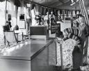
| Description: | Two boys drink from water fountains cooled with International Harvester milk coolers at the Ohio State Fair. The sign by the water fountain reads, "Here's ... |
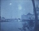
| Date: | 1893 |
|---|---|
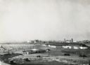
| Description: | View of the Columbian Exposition grounds from Lake Michigan. |
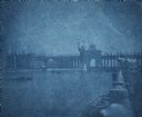
| Date: | 1893 |
|---|---|
| Description: | Cyanotype scenic view of the 1893 Chicago World's Columbian Exposition grounds showing the U.S. Government Building and a bridge over the lagoon. |
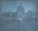
| Date: | 1893 |
|---|---|
| Description: | Cyanotype view of the Illinois Building at Chicago's World's Columbian Exposition showing a gondola and motor launch on the lagoon near a bridge. A wing of... |
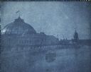
| Date: | 1893 |
|---|---|
| Description: | A cyanotype view of the Horticulture Building at the World's Columbian Exposition with the dome of the Illinois Building in the background. There is a mot... |
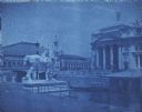
| Date: | 1893 |
|---|---|
| Description: | A cyanotype view of the central basin, Peristyle and Statue of the Republic. There are several boats on the basin. On the right is a large statue of a bu... |
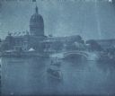
| Date: | 1893 |
|---|---|
| Description: | A cyanotype view across lagoon from shoreline of the U.S. Government Building (right), and the Fisheries building (left). There is a bridge over the lagoon... |
| Date: | 1893 |
|---|---|
| Description: | A cyanotype view of the World's Columbian Exposition grounds from near the North Loop elevated railway station, showing the glass dome of the Horticulture ... |
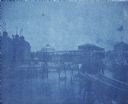
| Date: | 1893 |
|---|---|
| Description: | A cyanotype view of the Agriculture Building (right) and Manufactures and Liberal Arts Building (left) from the bank of the South Canal at the World's Colu... |

| Date: | 1893 |
|---|---|
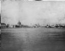
| Description: | View of the canal area of the Columbian Exposition grounds looking north from near the front of the Machinery building (at left). The South canal is in the... |

| Date: | 1891 |
|---|---|
| Description: | Color illustration of the grounds and buildings of the 1893 World's Fair or Columbian Exposition. |

| Date: | 1860 |
|---|---|
| Description: | Map showing a plat of the city, land ownership by name, wards by number, local streets, buildings, fair grounds, nurseries, and part of Rock River. The map... |

| Date: | 1875 |
|---|---|
| Description: | This map shows land ownership by name, plat of town, local streets, fairgrounds, part of White and Fox Rivers. The map includes illustrations of buildings ... |

| Date: | 1938 |
|---|---|
| Description: | This map shows plat of town, land ownership by name, city limits, section boundaries, wards, local roads, railroads, parks, fairgrounds, cemeteries, locati... |
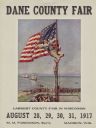
| Date: | 1917 |
|---|---|
| Description: | Advertisement featuring a painting by artist Henry Mosler, dated 1915, titled "The Stars and Stripes Forever." In the painting a young man dressed in cut-o... |

| Date: | 1935 |
|---|---|
| Description: | This blue lined map shows the major roads and cities of Wisconsin. The map includes an index, hotel and cafe advertisements, as well as advertisements for ... |

| Date: | 1935 |
|---|---|
| Description: | This blue lined map ("compliments of Black Eagle Oil Company") shows the major roads and cities of Wisconsin. The map includes an index, hotel and cafe adv... |
If you didn't find the material you searched for, our Library Reference Staff can help.
Call our reference desk at 608-264-6535 or email us at: