 Filter: Categories of Wisconsin Historical Images
Filter: Subject of Express highways
Filter: Categories of Wisconsin Historical Images
Filter: Subject of Express highways

| Date: | 1930 |
|---|---|
| Description: | This map shows communities, state roads, county roads, railroads, lakes and rivers in the county. Areas marked in red are lands tax deeded to the county. |

| Date: | 1975 |
|---|---|
| Description: | This map shows nature trails, public attractions, public hunting and fishing grounds, dams, waysides, lakes, highways, and roads. The upper right corner in... |

| Date: | 1936 |
|---|---|
| Description: | This map shows road surfaces, construction, flying fields, seaplane landings, populations of cities and towns, and ferry routes of Wisconsin and some of th... |

| Date: | 1937 |
|---|---|
| Description: | This map shows the major roads, cities, towns, lakes, and rivers of Wisconsin and some of the neighboring states. The front includes an add for Coca-Cola, ... |

| Date: | 1937 |
|---|---|
| Description: | This map shows the major cities, towns, highways, roads, lakes, and rivers of Wisconsin and some of the neighboring states. An index is included on the fro... |

| Date: | 1952 |
|---|---|
| Description: | This map shows lakes, rivers, railroads, highways, roads, hunting grounds and trails around Flambeau Flowage and Boulder Junction in the north, to Brantwoo... |

| Date: | 1952 |
|---|---|
| Description: | This map shows hunting areas, lakes, rivers, railroads, highways, roads, and trails around Clam Lake, Glidden, and Flambeau Flowage in the north, to Hawkin... |
| Date: | 1955 |
|---|---|
| Description: | This set of 32 maps and an index show the (then) proposed route of the Wisconsin Turnpike. The index shows the entire route of the turnpike, and the major ... |

| Date: | 10 2013 |
|---|---|
| Description: | View through car windshield of road signs above Interstate 90. The exit for highway 12/18 towards Cambridge is on the right, and the exit for 12/18 towards... |
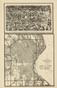
| Date: | 1932 |
|---|---|
| Description: | This map shows a large map on the bottom with marked routes. City blocks are shown but not labeled. Lake Michigan is labeled on the far right. The top of t... |
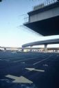
| Date: | |
|---|---|
| Description: | Incompleted overpass highway above a parking lot in Milwaukee. |

| Date: | |
|---|---|
| Description: | Long exposure at night of cars driving on the interstate near Highway X. |

| Date: | |
|---|---|
| Description: | Aerial view of the sprawling Milwaukee interchange at night. |

| Date: | 08 1980 |
|---|---|
| Description: | Two men holding a banner that reads: "Re-think I-43" in protest of the newly built highway. The highway runs from Green Bay to Beloit by way of Milwaukee. |

| Date: | 1915 |
|---|---|
| Description: | This map displays various automobile routes through the state of Wisconsin and parts of Illinois, Iowa, Minnesota, and Michigan. Cities, counties, Lake Mic... |

| Date: | 1915 |
|---|---|
| Description: | This map shows highways in the state and includes in the left bottom margin information on the population to be served by proposed roads. There are handwri... |

| Date: | 1920 |
|---|---|
| Description: | The map shows the entire state with cities, rivers, and lakes labeled. The upper and right margin include inset maps of Racine, Milwaukee, Waukesha, Applet... |

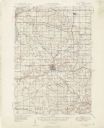
| Date: | 1930 |
|---|---|
| Description: | This map shows the entire state plus portions of Illinois, Iowa, Minnesota, and Michigan outlined in blue. The map shows roads, state parks (black triangle... |

| Date: | 1929 |
|---|---|
| Description: | This map of the entire state includes portions of Illinois, Iowa, Michigan, and Minnesota. The map shows U.S., state, and county highways, roads, campsites... |
If you didn't find the material you searched for, our Library Reference Staff can help.
Call our reference desk at 608-264-6535 or email us at:
