 Filter: Categories of Wisconsin Historical Images
Filter: Subject of Express highways
Filter: Subject of traffic signs and signals
Filter: Categories of Wisconsin Historical Images
Filter: Subject of Express highways
Filter: Subject of traffic signs and signals

| Date: | 1954 |
|---|---|
| Description: | Elevated view of a newly opened divided four lane highway. |
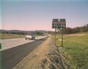
| Date: | 10 1961 |
|---|---|
| Description: | An Interstate I-90/94 sign near Portage taken by the Division of Tourism. |
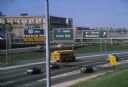
| Date: | 1981 |
|---|---|
| Description: | Fond du Lac Avenue (State Highway 145) exit from Interstate I-43 in Milwaukee. As originally conceived, the interstate system in Wisconsin was to consist ... |
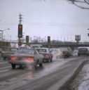
| Date: | 02 1977 |
|---|---|
| Description: | Automobile exhaust on a cold February morning in Milwaukee. |

| Date: | 1930 |
|---|---|
| Description: | Elevated view of two men driving an International truck on U.S. Highway 75 between Breckenridge and Moorehead in Minnesota. |
| Date: | 06 01 1966 |
|---|---|
| Description: | Highway County CTH "N" looking southeast. The white building on the right is the Marathon Town Hall. |

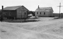
| Date: | 1930 |
|---|---|
| Description: | Exterior view of the Triangle filling station on Highway 12, which sold gasoline, ice, and other items. A man stands in front by the gas pump, and a map of... |

| Date: | 1961 |
|---|---|
| Description: | An International DF 405 truck owned by Lucky Lager drives down a highway away. The Lucky Lager factory is in the background. |

| Date: | 06 1980 |
|---|---|
| Description: | "In the foreground is the intersection of Hwy D & Hwy 175. Beyond it is Allen Road." |
| Date: | 02 1979 |
|---|---|
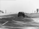
| Description: | Winter scene with a car on Hwy. 41 near in Dodge Co., Wisconsin. Caption: "On a cold, windy day, snow drifts across Hwy 41." |

| Date: | 03 1984 |
|---|---|
| Description: | "Traveling west over the Theresa Marsh, Hwy 28 intersects Hwy 175 at this intersection." |

| Date: | 1923 |
|---|---|
| Description: | This early road map shows the system of roads in Wisconsin, northern Illinois, northeastern Iowa, southeastern Minnesota, and the western portion of Michig... |

| Date: | 06 1995 |
|---|---|
| Description: | "An overpass over Hwy 41 is being built for Soo Road. The camera faces west with the Tom O'Connor farm in the distance." |

| Date: | 1961 |
|---|---|
| Description: | Evacuation route out of Milwaukee. View from the side of the road looking downhill towards the rear of a Wisconsin State Patrol cruiser parked on the right... |

| Date: | 10 2013 |
|---|---|
| Description: | View through car windshield of road signs above Interstate 90. The exit for highway 12/18 towards Cambridge is on the right, and the exit for 12/18 towards... |
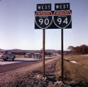
| Date: | 10 1961 |
|---|---|
| Description: | View from roadside of a road sign for west I90 and west I94. Cars are driving down the freeway on the left. |

| Date: | 05 1939 |
|---|---|
| Description: | View down median of road towards a truck parked on the scales of a weigh station in the center of Highway 41 just north of the Wisconsin/Illiinois state li... |
If you didn't find the material you searched for, our Library Reference Staff can help.
Call our reference desk at 608-264-6535 or email us at: