Filter: Categories of Wisconsin Historical Images
Filter: Subject of Express highways
Filter: Subject of human settlements
Filter: Reproduction Rights of For Sale
Filter: Categories of Wisconsin Historical Images
Filter: Subject of Express highways
Filter: Subject of human settlements
Filter: Reproduction Rights of For Sale
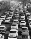
| Date: | 1957 |
|---|---|
| Description: | Elevated view of city traffic of bumper-to-bumper cars leaving Milwaukee County Stadium after the 1957 World Series. |

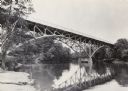
| Date: | 1930 |
|---|---|
| Description: | View of bridge and Brule River monument. Placed where the Brule River is crossed by the Memorial Highway from Superior to Brule and Ashland (Highway 2). |

| Date: | 1965 |
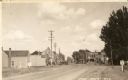
|---|---|
| Description: | Aerial view of town and Highway 66. |

| Date: | 1955 |
|---|---|
| Description: | Aerial view of La Crosse, with Onalaska in the background. The highway is U.S. Highway 53 and the State Highway 35. |

| Date: | 09 1962 |
|---|---|
| Description: | The Mississippi River along Highway 35. |

| Date: | 1955 |
|---|---|
| Description: | Aerial view of Mineral Point showing State Highway 23-39 under construction. |

| Date: | 1955 |
|---|---|
| Description: | An aerial view of Mineral Point showing the construction of State Highway 23-39. |

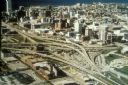
| Date: | 1965 |
|---|---|
| Description: | Aerial view of early construction at the Marquette Interchange in Milwaukee, the junction of Interstate Highways I94 and I43. Construction began in 1964, ... |
| Date: | |
|---|---|
| Description: | Aerial view of the first Marquette Interchange, photographed some time after its completion in 1968. |
| Date: | 1981 |
|---|---|
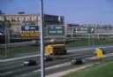
| Description: | Fond du Lac Avenue (State Highway 145) exit from Interstate I-43 in Milwaukee. As originally conceived, the interstate system in Wisconsin was to consist ... |

| Date: | 04 01 1975 |
|---|---|
| Description: | The bridge over the Milwaukee Harbor named in honor of former Mayor Daniel Hoan. The bridge was constructed between 1970 and 1972, but during the period de... |

| Date: | 1918 |
|---|---|
| Description: | "The playground of the Middle West." Showing the Numbered and Marked State Trunk Highway System and the Principal Secondary Highways; also locates Points o... |
| Date: | 02 1977 |
|---|---|
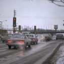
| Description: | Automobile exhaust on a cold February morning in Milwaukee. |

| Date: | 1913 |
|---|---|
| Description: | Wisconsin map showing fifteen hundred miles of national highways proposed by the National Highways Association. Scale: 1:2,500,000. These highways will dir... |
| Date: | 1969 |
|---|---|
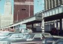
| Description: | View of the construction of the World Trade Center from a nearby parking lot. |

| Date: | 1969 |
|---|---|
| Description: | A man is driving a construction truck in the shadow cast by what appears to be an elevated highway. A sign for the "Brooklyn Battery Tunnel" is on one of t... |

| Date: | 1950 |
|---|---|
| Description: | Divided highway is South Chase Avenue between West Lincoln Avenue (2300) and East Oklahoma Avenue (3100). |

| Date: | 1937 |
|---|---|
| Description: | Official state highway map, with insets of cities. |
If you didn't find the material you searched for, our Library Reference Staff can help.
Call our reference desk at 608-264-6535 or email us at: