 Filter: Categories of Wisconsin Historical Images
Filter: Subject of Express highways
Filter: Subject of cities and towns
Filter: Categories of Wisconsin Historical Images
Filter: Subject of Express highways
Filter: Subject of cities and towns

| Date: | 1937 |
|---|---|
| Description: | Official state highway map, with insets of cities. |

| Date: | 1961 |
|---|---|
| Description: | View over beltline of University of Wisconsin-Madison Arboretum along Lake Wingra. Lake Mendota is on upper left, and Lake Monona is on the right, with the... |
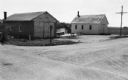
| Date: | 06 01 1966 |
|---|---|
| Description: | Highway County CTH "N" looking southeast. The white building on the right is the Marathon Town Hall. |

| Date: | 1930 |
|---|---|
| Description: | Exterior view of the Triangle filling station on Highway 12, which sold gasoline, ice, and other items. A man stands in front by the gas pump, and a map of... |
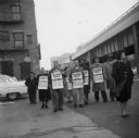
| Date: | 11 1955 |
|---|---|
| Description: | United Packinghouse Workers of America picketers protest the hiring of temporary scab labor by the Colonial Provisions Company. Although no location or dat... |

| Date: | 1962 |
|---|---|
| Description: | Cover of a brochure advertising International Fleetstar BBC Series 1900 and 2000 semi-trucks. The cover features the IHC logo and an illustration of a man ... |

| Date: | 1984 |
|---|---|
| Description: | An International heavy S-2 cement mixer painted orange is at the top of a hill. In the background is a highway, part of which is under construction. |

| Date: | 1961 |
|---|---|
| Description: | An International DF 405 truck owned by Lucky Lager drives down a highway away. The Lucky Lager factory is in the background. |
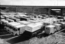
| Date: | 1959 |
|---|---|
| Description: | Elevated view of International Metro trucks parked beside a highway overpass. A group of cars are parked in the background on the left. |
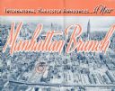
| Date: | 1937 |
|---|---|
| Description: | Cover of a brochure celebrating a new International Harvester Manhattan branch, featuring an aerial photograph of Manhattan, including the corner of West 4... |

| Date: | 1944 |
|---|---|
| Description: | International highway truck operated by Mistletoe Express Service, Inc. Original caption reads: "The truck shown was traveling on a busy highway leading ou... |
| Date: | 1944 |
|---|---|
| Description: | Continental Transportation Lines, Inc. operating an International semi-truck on a highway with an industrial area in the background. Original caption reads... |

| Date: | 1944 |
|---|---|
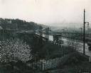
| Description: | Continental Transportation Lines, Inc. operating an International semi-truck (tractor-trailer) on a road with a hazy view of a bridge, a body of water and ... |
| Date: | 1944 |
|---|---|
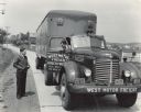
| Description: | International KR-11 truck with semi-trailer (semi-truck) parked on a rural road. The truck was owned and operated by West Motor Freight of Boyertown, Penns... |
| Date: | 1944 |
|---|---|
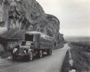
| Description: | International KR-11 truck with semi-trailer (semi-truck) operated by Northwest Freight Lines. The truck is on a mountain road next to a large rock formatio... |

| Date: | 1944 |
|---|---|
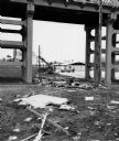
| Description: | Continental Transportation Lines, Inc. operating an International truck tractor on an urban highway. A bridge, houses and industrial buildings are in the b... |
| Date: | 1974 |
|---|---|
| Description: | "The Lomira Legion building is framed in the arch of the Highway 67 overhead." |

| Date: | 1923 |
|---|---|
| Description: | This map shows trails, some in red, for automobiles. The right margin includes a key of markings as well as Minnesota and Wisconsin Highway signs. Communit... |

| Date: | 1915 |
|---|---|
| Description: | A map of Wisconsin that shows 1,900 miles of national highways proposed for the state. The map also includes the names and locations of towns and cities th... |

| Date: | 1923 |
|---|---|
| Description: | This early road map shows the system of roads in Wisconsin, northern Illinois, northeastern Iowa, southeastern Minnesota, and the western portion of Michig... |
If you didn't find the material you searched for, our Library Reference Staff can help.
Call our reference desk at 608-264-6535 or email us at: