 Filter: Categories of Wisconsin Historical Images
Filter: Subject of Express highways
Filter: Subject of cities and towns
Filter: Year of 1900-1999
Filter: Year of 1940-1949
Filter: Categories of Wisconsin Historical Images
Filter: Subject of Express highways
Filter: Subject of cities and towns
Filter: Year of 1900-1999
Filter: Year of 1940-1949

| Date: | 1944 |
|---|---|
| Description: | International highway truck operated by Mistletoe Express Service, Inc. Original caption reads: "The truck shown was traveling on a busy highway leading ou... |
| Date: | 1944 |
|---|---|
| Description: | Continental Transportation Lines, Inc. operating an International semi-truck on a highway with an industrial area in the background. Original caption reads... |

| Date: | 1944 |
|---|---|
| Description: | Continental Transportation Lines, Inc. operating an International semi-truck (tractor-trailer) on a road with a hazy view of a bridge, a body of water and ... |
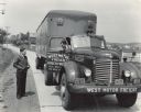
| Date: | 1944 |
|---|---|
| Description: | International KR-11 truck with semi-trailer (semi-truck) parked on a rural road. The truck was owned and operated by West Motor Freight of Boyertown, Penns... |
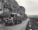
| Date: | 1944 |
|---|---|
| Description: | International KR-11 truck with semi-trailer (semi-truck) operated by Northwest Freight Lines. The truck is on a mountain road next to a large rock formatio... |

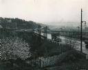
| Date: | 1944 |
|---|---|
| Description: | Continental Transportation Lines, Inc. operating an International truck tractor on an urban highway. A bridge, houses and industrial buildings are in the b... |

| Date: | 1944 |
|---|---|
| Description: | This nine-part map from the U.S. Bureau of Public Roads identifies federal and state highways in Wisconsin by pavement type. County, forest, park, and publ... |

| Date: | 12 25 1942 |
|---|---|
| Description: | This hand-drawn map shows the highways and features in the Rock Lake-Lake Mills area in the towns of Aztalan and Lake Mills, Jefferson County, Wisconsin. T... |

| Date: | 1946 |
|---|---|
| Description: | Map of Kewaunee County, Wisconsin, shows towns, cities and villages, roads and highways, railroads, schools, lighthouses, place names, town divisions, comm... |

| Date: | 1942 |
|---|---|
| Description: | This map shows surfaces and types of highways. A legend and three county and two local area inset maps are included. The bottom left margin reads: "Traffi... |

| Date: | 1941 |
|---|---|
| Description: | Color coded map in pink, yellow, green, and brown of Milwaukee County State and County trunk highways. The map includes a legend of symbols: "STEAM RAIL RO... |

| Date: | 1946 |
|---|---|
| Description: | Color coded map in pink, yellow, green, and brown of Milwaukee County State and County trunk highways. The map includes a legend of symbols: "STEAM RAIL RO... |

| Date: | 1948 |
|---|---|
| Description: | This blue line print map shows highways, the scale of traffic volume, and average 24 hour traffic. Also included are inset maps of Appleton, Neenah, and Me... |
If you didn't find the material you searched for, our Library Reference Staff can help.
Call our reference desk at 608-264-6535 or email us at: