 Filter: Categories of Wisconsin Historical Images
Filter: Subject of Express highways
Filter: Subject of cities and towns
Filter: Subject of signs and signboards
Filter: Categories of Wisconsin Historical Images
Filter: Subject of Express highways
Filter: Subject of cities and towns
Filter: Subject of signs and signboards
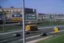
| Date: | 1981 |
|---|---|
| Description: | Fond du Lac Avenue (State Highway 145) exit from Interstate I-43 in Milwaukee. As originally conceived, the interstate system in Wisconsin was to consist ... |

| Date: | 1930 |
|---|---|
| Description: | Exterior view of the Triangle filling station on Highway 12, which sold gasoline, ice, and other items. A man stands in front by the gas pump, and a map of... |
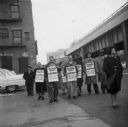
| Date: | 11 1955 |
|---|---|
| Description: | United Packinghouse Workers of America picketers protest the hiring of temporary scab labor by the Colonial Provisions Company. Although no location or dat... |

| Date: | 1961 |
|---|---|
| Description: | An International DF 405 truck owned by Lucky Lager drives down a highway away. The Lucky Lager factory is in the background. |

| Date: | 1923 |
|---|---|
| Description: | This early road map shows the system of roads in Wisconsin, northern Illinois, northeastern Iowa, southeastern Minnesota, and the western portion of Michig... |

| Date: | |
|---|---|
| Description: | Aerial view of the sprawling Milwaukee interchange at night. |
If you didn't find the material you searched for, our Library Reference Staff can help.
Call our reference desk at 608-264-6535 or email us at: