Filter: Categories of Wisconsin Historical Images
Filter: Subject of Express highways
Filter: Subject of cities and towns
Filter: Subject of architecture
Filter: Categories of Wisconsin Historical Images
Filter: Subject of Express highways
Filter: Subject of cities and towns
Filter: Subject of architecture
| Date: | 1981 |
|---|---|
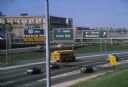
| Description: | Fond du Lac Avenue (State Highway 145) exit from Interstate I-43 in Milwaukee. As originally conceived, the interstate system in Wisconsin was to consist ... |

| Date: | 1969 |
|---|---|
| Description: | View of the construction of the World Trade Center from a nearby parking lot. |
| Date: | 06 01 1966 |
|---|---|
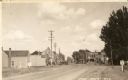
| Description: | Highway County CTH "N" looking southeast. The white building on the right is the Marathon Town Hall. |
| Date: | 11 1955 |
|---|---|
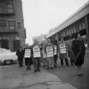
| Description: | United Packinghouse Workers of America picketers protest the hiring of temporary scab labor by the Colonial Provisions Company. Although no location or dat... |
| Date: | 1937 |
|---|---|
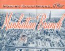
| Description: | Cover of a brochure celebrating a new International Harvester Manhattan branch, featuring an aerial photograph of Manhattan, including the corner of West 4... |

| Date: | 1944 |
|---|---|
| Description: | International highway truck operated by Mistletoe Express Service, Inc. Original caption reads: "The truck shown was traveling on a busy highway leading ou... |
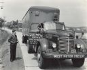
| Date: | 1944 |
|---|---|
| Description: | International KR-11 truck with semi-trailer (semi-truck) parked on a rural road. The truck was owned and operated by West Motor Freight of Boyertown, Penns... |
| Date: | 1974 |
|---|---|
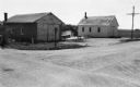
| Description: | "The Lomira Legion building is framed in the arch of the Highway 67 overhead." |

| Date: | 1926 |
|---|---|
| Description: | A topographic map of Green County, showing by contours and spot heights the topographic and natural features of the county. The contour intervals are 20 fe... |

| Date: | 1946 |
|---|---|
| Description: | Map of Kewaunee County, Wisconsin, shows towns, cities and villages, roads and highways, railroads, schools, lighthouses, place names, town divisions, comm... |

| Date: | 1926 |
|---|---|
| Description: | A map of Lincoln County, Wisconsin that shows the township and range grid, towns, cities and villages, lakes and streams, residences, churches, school hous... |

| Date: | 1970 |
|---|---|
| Description: | Color photo of an International C-O 4070A Transtar truck hauling the metal statue "St. Francis of the Guns" on a trailer down a San Francisco highway. The ... |

| Date: | 1964 |
|---|---|
| Description: | Indexed map. Street names are to the left, map is to the right. Lakes, streets, highways, and points of interest are labelled. |

| Date: | 1933 |
|---|---|
| Description: | This blueprint map shows lakes, roads, railroads, townships and sections. A legend is also included that shows highway surface types. |

| Date: | 1968 |
|---|---|
| Description: | This blue line print map shows proposed changes reserving railroad right-of-ways for future highways, land plots, as well as Lake Monona and Lake Mendota. |

| Date: | |
|---|---|
| Description: | Aerial view looking north along Stoughton Road from south of Pflaum Road. |
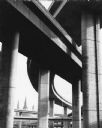
| Date: | 1971 |
|---|---|
| Description: | A view of the underside of a highway interchange. Steeples of a church are in the background. |
If you didn't find the material you searched for, our Library Reference Staff can help.
Call our reference desk at 608-264-6535 or email us at: