 Filter: Categories of Wisconsin Historical Images
Filter: Subject of Exploration
Filter: Subject of science
Filter: Subject of exploration
Filter: Categories of Wisconsin Historical Images
Filter: Subject of Exploration
Filter: Subject of science
Filter: Subject of exploration

| Date: | 1823 |
|---|---|
| Description: | In 1823 U.S. Army major Stephen H. Long led an expedition of scientific, trade, and military investigation up the Mississippi River and the Red River of th... |
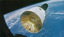
| Date: | 12 15 1965 |
|---|---|
| Description: | The Gemini 7 spacecraft as photographed by the Gemini 6 crew, 160 miles above the earth. The two-man crew of Gemini 7 included Frank Borman and James A. L... |
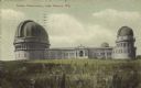
| Date: | 1905 |
|---|---|
| Description: | View across field towards the observatory. Caption reads: "Yerkes Observatory, Lake Geneva, Wis." |

| Date: | 1935 |
|---|---|
| Description: | The entrance to Yerkes Observatory. Caption reads: "Entrance, Yerkes Observatory, University of Chicago, at Williams Bay, Wis." |

| Date: | 1836 |
|---|---|
| Description: | This map depicts Wisconsin and Michigan territories in 1836. It includes the area from Michigan to the Missouri River and Lake Winnipeg, and it shows the e... |

| Date: | 08 22 1961 |
|---|---|
| Description: | Portrait of Dr. Krafft A. Ehricke, program director of the astronautics division of General Dynamics Corporation. He spoke at the Wisconsin Union Theater t... |

| Date: | 1790 |
|---|---|
| Description: | An updated and corrected version of Robert de Vaugondy's 1750 map "Amérique Septentrionale: Dressée sur les Relations les Plus Modernes des Voyageurs et Na... |

| Date: | 1783 |
|---|---|
| Description: | This map is hand-colored and shows the boundaries of British, Spanish, and the newly recognized American claims, as well as the fishing rights granted to F... |

| Date: | 1676 |
|---|---|
| Description: | Detailed map of North and South America. Cities, towns, forests, and mountains are shown pictorially. Duval labels regions, islands, cities, lakes, and Nat... |

| Date: | 1746 |
|---|---|
| Description: | Detailed map of the western hemisphere and part of Africa and Europe. Islands, cities, settlements, rivers, lakes, countries, and regions are marked. Mount... |

| Date: | |
|---|---|
| Description: | James Kitchell with camera operator in foreground. Men sitting at tables surrounding them are, from left: John Young, Scott Carpenter, Ed White, John Glenn... |

| Date: | |
|---|---|
| Description: | James Kitchell, standing on right, with two men next to him: John Glenn Jr. on the left, and unknown person in the center. |
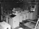
| Date: | 1960 |
|---|---|
| Description: | Caption reads: "Tinius Olsen Automatic Balance Correcting Machine for Engine Crankshafts." |
If you didn't find the material you searched for, our Library Reference Staff can help.
Call our reference desk at 608-264-6535 or email us at: