 Filter: Categories of Wisconsin Historical Images
Filter: Subject of Engraving
Filter: Year of 1700-1799
Filter: Categories of Wisconsin Historical Images
Filter: Subject of Engraving
Filter: Year of 1700-1799

| Date: | 1766 |
|---|---|
| Description: | Map of the region south of Lake Erie to the Ohio River. It shows forts, towns, Native American towns, mines, roads, mountains, swamps, lakes, and rivers. T... |

| Date: | 1791 |
|---|---|
| Description: | Small map of an abandoned Native American town and fort at the junction of the Ohio and Muskingum River. It shows the fortifications, an outline of the tow... |

| Date: | 1755 |
|---|---|
| Description: | Map of the Great Lakes region during the French and Indian War. It shows in great detail the territories, borders and boundary lines, Native American tribe... |
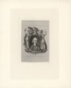
| Date: | 1774 |
|---|---|
| Description: | Engraved portrait of Samuel Adams, a Founding Father of the United States and 4th Governor of Massachusetts (1792-1794). Adams' portrait is framed in an ov... |
If you didn't find the material you searched for, our Library Reference Staff can help.
Call our reference desk at 608-264-6535 or email us at: