Filter: Categories of Wisconsin Historical Images
Filter: Subject of Engraving
Filter: Subject of women
Filter: Subject of water
Filter: Categories of Wisconsin Historical Images
Filter: Subject of Engraving
Filter: Subject of women
Filter: Subject of water

| Date: | 1871 |
|---|---|
| Description: | Drawing of the Peshtigo Fire, showing people seeking refuge in the Peshtigo River. |
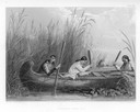
| Date: | 1884 |
|---|---|
| Description: | Three women in a canoe harvest wild rice. |
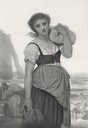
| Date: | 1883 |
|---|---|
| Description: | Engraving of a woman carrying a bundle of clothing and standing with her back to the sea. Behind her other women are in the process of doing wash in the wa... |

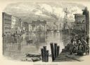
| Date: | 1857 |
|---|---|
| Description: | Bird's-eye view of Madison over rooftop and across lake with sailboats and steamers. A group of people are standing on a viewing platform on the roof in th... |

| Date: | 1655 |
|---|---|
| Description: | Christopher Columbus begins his first expedition, 1492. |

| Date: | 1784 |
|---|---|
| Description: | Plate 41. Scene from Cook's Third Expedition, 1776-1779, while in Alaska. |

| Date: | 1835 |
|---|---|
| Description: | Two-story home with sloping roof. One man is whipping a team of eight cattle while another man drives the plow behind them. To the left stands a man near a... |

| Date: | 1698 |
|---|---|
| Description: | An illustration of two men looking out at Niagara Falls. The Niagara Falls in Jean Louis Hennepin’s A new discovery of a vast country in America (London: M... |

| Date: | 05 27 1934 |
|---|---|
| Description: | A sensational newspaper article about a newlywed couple encountering a sea serpent which resembles the Loch Ness monster. |

| Date: | 1720 |
|---|---|
| Description: | Double hemispherical world map showing routes of Tasman, Magellan, Mendana, etc. Relief shown pictorially. Title in oak wreath cartouche. Map between four ... |

| Date: | 1696 |
|---|---|
| Description: | Engraved and hand-colored map of Ethiopia, from Blaeu's General Atlas. Map title is framed by a man and a woman, both wearing head turbans, who are standin... |

| Date: | 1877 |
|---|---|
| Description: | Engraving of the Peck Cabin, after the painting by Mrs. E.E. Bailey. Caption at bottom reads: "First House in Madison. 1837." |

| Date: | 1703 |
|---|---|
| Description: | Map of the Golf of Mexico and surrounding countries from the Great Lakes down to the northern most parts of South America. L'Isle labels cities, towns, and... |

| Date: | 1746 |
|---|---|
| Description: | Map of North America from the southern portion of James Bay to Florida. It shows the colonies, cities, Native American land, and topological and geographic... |

| Date: | 1758 |
|---|---|
| Description: | This map of the north-west hemisphere shows the cities, lakes, rivers, mountains, and political borders. In the upper left corner sits a decorative cartouc... |

| Date: | 1627 |
|---|---|
| Description: | Map of North and South America showing settlements, rivers, lakes, mountains, islands and regions of the western hemisphere. It includes an inset map of Gr... |

| Date: | 1630 |
|---|---|
| Description: | One of the few maps by Dutch cartographer Willem Blaeu depicting the Americas, this map shows regions, settlements, islands, mountains, forests, rivers, an... |

| Date: | 1685 |
|---|---|
| Description: | A detailed map of the western hemisphere showing cities, settlements, Native American land, rivers, lakes, mountains, the Great Lakes, and California as an... |
If you didn't find the material you searched for, our Library Reference Staff can help.
Call our reference desk at 608-264-6535 or email us at: