 Filter: Categories of Wisconsin Historical Images
Filter: Subject of Engraving
Filter: Subject of weapons
Filter: Subject of botany
Filter: Categories of Wisconsin Historical Images
Filter: Subject of Engraving
Filter: Subject of weapons
Filter: Subject of botany
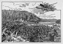
| Date: | 1845 |
|---|---|
| Description: | Illustration of Chippewa and Sioux Indians battling each other at the Brule River. Wood engraving from Armstrong, "Early Life Among The Indians." |

| Date: | |
|---|---|
| Description: | "Death Whoop" an engraving after a drawing by Seth Eastman from the American Aboriginal Portfolio. |
| Date: | |
|---|---|
| Description: | Steel engraving of the first major battle of the Civil War, fought in Virginia, near the Manassas, Virginia, railway junction, after which the battle is ca... |

| Date: | 1870 |
|---|---|
| Description: | Magazine illustration of the home, titled: "Soldiers' National Asylum at Milwaukee, Wisconsin". The building is in the background, and in the foreground ar... |

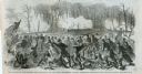
| Date: | 1615 |
|---|---|
| Description: | Drawing of Native Americans chasing deer into an enclosure during a hunt. |
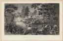
| Date: | 07 21 1861 |
|---|---|
| Description: | Depiction of the battlefield. Engraved by J.C. McRae and drawn by W. Momberger. |
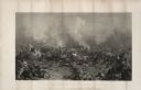
| Date: | 1863 |
|---|---|
| Description: | An engraving of the Battle of Gettysburg, after the painting by P.F. Rothermel. |
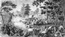
| Date: | 03 15 1862 |
|---|---|
| Description: | Engraved Illustration for the story titled: "The Fight at Fort Donelson". The illustration shows the Second Iowa Volunteers regiment attacking Confederate ... |

| Date: | 1746 |
|---|---|
| Description: | A map of the western hemisphere, including parts of western Europe and Africa, showing the division of the Americas by the European powers. Weapons and fol... |

| Date: | 1755 |
|---|---|
| Description: | This map shows the eastern half of North America during the French and Indian war, including cities, borders, Native American Land, forts, and detailed geo... |

| Date: | 1790 |
|---|---|
| Description: | An updated and corrected version of Robert de Vaugondy's 1750 map "Amérique Septentrionale: Dressée sur les Relations les Plus Modernes des Voyageurs et Na... |

| Date: | 1667 |
|---|---|
| Description: | Map of Virginia depicting the discoveries detailed by John Smith in his exploration of the region. It shows Jamestown, Native American tribes and villages,... |
If you didn't find the material you searched for, our Library Reference Staff can help.
Call our reference desk at 608-264-6535 or email us at: