Filter: Categories of Wisconsin Historical Images
Filter: Subject of Engraving
Filter: Subject of water
Filter: Subject of recreation
Filter: Categories of Wisconsin Historical Images
Filter: Subject of Engraving
Filter: Subject of water
Filter: Subject of recreation
| Date: | 1832 |
|---|---|
| Description: | Travellers setting up camp along the Missouri River. |
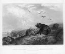
| Date: | 1832 |
|---|---|
| Description: | Punka Indians encamped on the banks of the Missouri River and canoeing in river. |

| Date: | 1832 |
|---|---|
| Description: | Fort Clark, on the Missouri River, February 1834. |
| Date: | 03 09 1878 |
|---|---|
| Description: | Illustration by N.A. Greenback of ice-skaters and iceboats featuring the new Poughkeepsie design of pivoting runners. A key at the bottom of the image iden... |

| Date: | 1857 |
|---|---|
| Description: | Bird's-eye view of Madison over rooftop and across lake with sailboats and steamers. A group of people are standing on a viewing platform on the roof in th... |
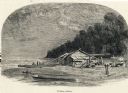
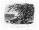
| Date: | |
|---|---|
| Description: | Engraving of a wooden shack on a Lake Michigan beach surrounded by rowboats, a campfire, and a wooded bluff. Two men stand on the beach near the water. |
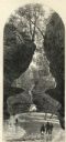
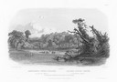
| Date: | 1874 |
|---|---|
| Description: | Engraved view of Rood's Glen. A boy plays with a toy boat at bottom left while two men and a woman talk at bottom right. Two other figures can be seen in t... |

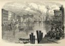
| Date: | 1871 |
|---|---|
| Description: | Engraved view of Kenosha harbor. A group of men fish from a pier in the foreground while several boats float through the harbor. A tug is pulling a large s... |

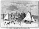
| Date: | 1877 |
|---|---|
| Description: | Engraving of the Peck Cabin, after the painting by Mrs. E.E. Bailey. Caption at bottom reads: "First House in Madison. 1837." |

| Date: | 1720 |
|---|---|
| Description: | One of Herman Moll's most famous maps, often referred to as The Beaver Map for its elaborate engraved inset depicting and describing beavers building a dam... |

| Date: | 1715 |
|---|---|
| Description: | One of Herman Moll's most famous maps, often referred to as The Codfish Map, it shows rivers and portages, cities, Indian villages, wind directions, routes... |

| Date: | 1750 |
|---|---|
| Description: | Map of the northeast corner of America and Canada with hand-colored boundaries. The map shows colonies, Native American nations, fishing areas, and detaile... |

| Date: | 1790 |
|---|---|
| Description: | An updated and corrected version of Robert de Vaugondy's 1750 map "Amérique Septentrionale: Dressée sur les Relations les Plus Modernes des Voyageurs et Na... |

| Date: | 1776 |
|---|---|
| Description: | Map of New Jersey and New York, showing cities, forts, roads, counties, townships, land grants, rivers, lakes and several topographical features. Much of t... |

| Date: | 1759 |
|---|---|
| Description: | Map of North and South America showing regions, colonies, cities and settlements, rivers, lakes, and Native American land. Near the bottom left an inset ma... |

| Date: | 1759 |
|---|---|
| Description: | Map of north eastern Canada and parts of New England, showing settlements, cities, portages, Native American land, mountains, lakes, and rivers. The unusua... |
If you didn't find the material you searched for, our Library Reference Staff can help.
Call our reference desk at 608-264-6535 or email us at: