 Filter: Categories of Wisconsin Historical Images
Filter: Subject of Engraving
Filter: Subject of transportation
Filter: Subject of writing
Filter: Categories of Wisconsin Historical Images
Filter: Subject of Engraving
Filter: Subject of transportation
Filter: Subject of writing
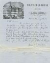
| Date: | 1857 |
|---|---|
| Description: | Letter on stationery featuring an engraving of an exterior view of the Milwaukee House showing horse-drawn vehicles and people standing on the sidewalk in ... |

| Date: | 1776 |
|---|---|
| Description: | This was one of the first maps available for the general British populace featuring America during the Revolutionary War. It includes forts, cities, topogr... |

| Date: | 1758 |
|---|---|
| Description: | Map showing lakes, rivers, cities, Native American land, and the boundaries of French and English claims in America and Canada north of New York. A title c... |
If you didn't find the material you searched for, our Library Reference Staff can help.
Call our reference desk at 608-264-6535 or email us at: