Filter: Categories of Wisconsin Historical Images
Filter: Subject of Engraving
Filter: Subject of technology
Filter: Categories of Wisconsin Historical Images
Filter: Subject of Engraving
Filter: Subject of technology
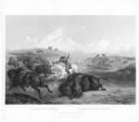
| Date: | 1845 |
|---|---|
| Description: | Illustration of Chippewa and Sioux Indians battling each other at the Brule River. Wood engraving from Armstrong, "Early Life Among The Indians." |
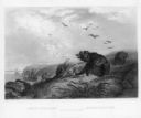
| Date: | 1845 |
|---|---|
| Description: | Engraving depicting the defeat of Black Hawk by General Henry Atkinson at the Battle of Bad Axe on August 2, 1832. The engraving depicts Federal Regulars a... |

| Date: | 03 02 1934 |
|---|---|
| Description: | A man in the camera room at the Wisconsin Engraving Co. plant, 109 S. Carroll Street, is making a halftone negative, the first step in making a photo engra... |
| Date: | 1655 |
|---|---|
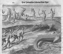
| Description: | Engraving made after a painting by Jacques Le Moyne de Morgues (died 1588) while on the Laudonnière Expedition in Florida, ca. 1564. |

| Date: | 1615 |
|---|---|
| Description: | Drawing of Native Americans chasing deer into an enclosure during a hunt. |
| Date: | 02 28 1863 |
|---|---|
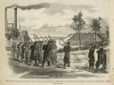
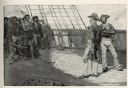
| Description: | The First Regiment of the Louisiana Native Guards disembarking at Fort Macomb, Louisiana. The fort is adjacent to the Venetian Isles community, now legally... |
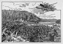
| Date: | 1819 |
|---|---|
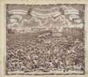
| Description: | A commemorative handkerchief created by a wood engraving on white cotton fabric. The scene is the Manchester Reform Meeting, in England. A crowd of demonst... |
| Date: | |
|---|---|
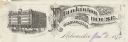
| Description: | Letterhead of Plankinton House in Milwaukee, Wisconsin, with a three-quarter view of the hotel and traffic in the street, including people on foot, on hors... |
| Date: | |
|---|---|
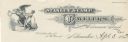
| Description: | Letterhead of Stanley & Camp, Jewelers, of Milwaukee, Wisconsin. Features a winged Father Time holding a large pocket watch in an extended hand, while a yo... |
| Date: | 04 1884 |
|---|---|
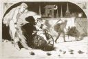
| Description: | An engraving depicting the impressment of American seamen by the British Navy during the period before the War of 1812. The image shows a group of American... |
| Date: | 01 1869 |
|---|---|
| Description: | Engraving after a drawing by Winslow Homer showing a crowned Baby New Year riding a velocipede through a hoop held by a woman, as the Grim Reaper, on the r... |

| Date: | 04 29 1934 |
|---|---|
| Description: | An illustrated, sensational article about giant robots replacing soldiers in fighting wars. |

| Date: | 07 1892 |
|---|---|
| Description: | Engraved illustration depicting Frank Lenz sitting on the edge of a railroad bridge holding his safety bicycle in front of him and his box camera on his ba... |
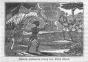
| Date: | 06 06 1860 |
|---|---|
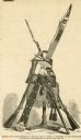
| Description: | An illustration of the enormous bowie knife that was presented to John F. Potter. |

| Date: | 1760 |
|---|---|
| Description: | A map of the world in two hemispheres, with the borders of the continents hand-colored. This map contains 14 spherical diagrams of the cosmos, portraying t... |

| Date: | 1755 |
|---|---|
| Description: | This map shows the eastern half of North America during the French and Indian war, including cities, borders, Native American Land, forts, and detailed geo... |

| Date: | 1790 |
|---|---|
| Description: | An updated and corrected version of Robert de Vaugondy's 1750 map "Amérique Septentrionale: Dressée sur les Relations les Plus Modernes des Voyageurs et Na... |

| Date: | 1667 |
|---|---|
| Description: | Map of Virginia depicting the discoveries detailed by John Smith in his exploration of the region. It shows Jamestown, Native American tribes and villages,... |
If you didn't find the material you searched for, our Library Reference Staff can help.
Call our reference desk at 608-264-6535 or email us at: