 Filter: Categories of Wisconsin Historical Images
Filter: Subject of Engraving
Filter: Subject of shorelines
Filter: Subject of ships
Filter: Categories of Wisconsin Historical Images
Filter: Subject of Engraving
Filter: Subject of shorelines
Filter: Subject of ships
| Date: | 10 1844 |
|---|---|
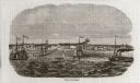
| Description: | A variant of a wood engraving dated October, 1844. Incorporated as the villige of Southport in 1841 (so-named because it was the southern-most natural harb... |

| Date: | |
|---|---|
| Description: | Letterhead of Johnson & Melaas, merchant tailors and cloth dealers, "Buyers of wool and Wisconsin leaf tobacco," with an engraving of a waterfront view of ... |

| Date: | 1755 |
|---|---|
| Description: | Map of the northeastern portion of America and Canada, east of the Hudson River and south from Labrador. It names regions, colonies, cities, numerous forts... |

| Date: | 1759 |
|---|---|
| Description: | Map of north eastern Canada and parts of New England, showing settlements, cities, portages, Native American land, mountains, lakes, and rivers. The unusua... |

| Date: | 10 1776 |
|---|---|
| Description: | Broadside map showing the British invasion of New York city in August and September of 1776. The map shows important cities, forts, roads, hills, mountains... |

| Date: | 1776 |
|---|---|
| Description: | Map of the Delaware Bay, River, their shoreline, made to aid ships in navigating to Philadelphia. It is oriented with north to the right and shows inlets, ... |
If you didn't find the material you searched for, our Library Reference Staff can help.
Call our reference desk at 608-264-6535 or email us at: