Filter: Categories of Wisconsin Historical Images
Filter: Subject of Engraving
Filter: Subject of shorelines
Filter: Subject of military art and science
Filter: Categories of Wisconsin Historical Images
Filter: Subject of Engraving
Filter: Subject of shorelines
Filter: Subject of military art and science

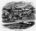
| Date: | 02 28 1863 |
|---|---|
| Description: | The First Regiment of the Louisiana Native Guards disembarking at Fort Macomb, Louisiana. The fort is adjacent to the Venetian Isles community, now legally... |
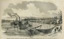
| Date: | 05 31 1862 |
|---|---|
| Description: | Engraved view of the Commisary [sic] depot of Major-General Halleck's army at Hamburg Landing. |
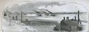
| Date: | 04 05 1862 |
|---|---|
| Description: | Engraved illustration for the story titled: "The Fight at Island No. 10". The view from the deck of a boat looks out at the approaching gun boats coming do... |

| Date: | 1887 |
|---|---|
| Description: | Engraving of Pittsburg Landing taken from a photograph a few days after the Battle of Shiloh (Tennessee), which occurred on April 6-7, 1862. The image sho... |

| Date: | 10 1776 |
|---|---|
| Description: | Broadside map showing the British invasion of New York city in August and September of 1776. The map shows important cities, forts, roads, hills, mountains... |

| Date: | 1781 |
|---|---|
| Description: | Map of North and South Carolina and Virginia towards the end of the Revolutionary War. It shows borders, counties, cities, court houses, bridges, chapels, ... |

| Date: | 1781 |
|---|---|
| Description: | Map of the southern portion of the Chesapeake Bay and surrounding lands. It shows counties, a few cities and towns, forts, roads, islands, topographical fe... |

| Date: | 1761 |
|---|---|
| Description: | Map of New Orleans with north oriented towards the upper right corner. It shows the land around the city, the Mississippi River, anchorages, roads leading ... |

| Date: | 1793 |
|---|---|
| Description: | Detailed topographical map of the Ohio River between Clarkville and Louisville. It shows plots of farmland, forest, islands, garden plots, houses, Fort Fe... |
If you didn't find the material you searched for, our Library Reference Staff can help.
Call our reference desk at 608-264-6535 or email us at: