Filter: Categories of Wisconsin Historical Images
Filter: Subject of Engraving
Filter: Subject of shorelines
Filter: Subject of hills
Filter: Categories of Wisconsin Historical Images
Filter: Subject of Engraving
Filter: Subject of shorelines
Filter: Subject of hills

| Date: | 1850 |
|---|---|
| Description: | Travelers in a rowing canoe on Lake Superior. |
| Date: | 1832 |
|---|---|
| Description: | Engraving of Indians on horseback along river with Indian grave on hill in background. |
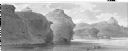
| Date: | 1832 |
|---|---|
| Description: | Remarkable hills on the Upper Missouri River (view 1). |
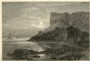
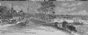
| Date: | 1874 |
|---|---|
| Description: | Engraved view of Maiden's Rock at Lake Pepin. A steamboat is on the Mississippi River. |

| Date: | 1755 |
|---|---|
| Description: | Map of the northeastern portion of America and Canada, east of the Hudson River and south from Labrador. It names regions, colonies, cities, numerous forts... |

| Date: | 10 1776 |
|---|---|
| Description: | Broadside map showing the British invasion of New York city in August and September of 1776. The map shows important cities, forts, roads, hills, mountains... |
If you didn't find the material you searched for, our Library Reference Staff can help.
Call our reference desk at 608-264-6535 or email us at: