Filter: Categories of Wisconsin Historical Images
Filter: Subject of Engraving
Filter: Subject of ships
Filter: Subject of clothing and dress
Filter: Categories of Wisconsin Historical Images
Filter: Subject of Engraving
Filter: Subject of ships
Filter: Subject of clothing and dress

| Date: | 1655 |
|---|---|
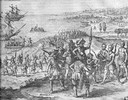
| Description: | Christopher Columbus begins his first expedition, 1492. |

| Date: | 1655 |
|---|---|
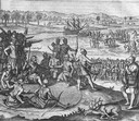
| Description: | Encounter with Indians during Christopher Columbus' first expedition in 1492. |
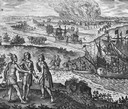
| Date: | 1655 |
|---|---|
| Description: | Scene on Hispaniola in 1500, when Columbus was forced to return to Spain after a new adminstrator had arrived. |
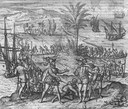
| Date: | 1655 |
|---|---|
| Description: | Scene from Drake Expedition on coast of California, ca. 1579. Francis Drake on the Coast of New Albion, California. |
| Date: | 1655 |
|---|---|
| Description: | Scene from Jamestown Settlement in Virginia, 1610. |
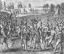
| Date: | 1655 |
|---|---|
| Description: | Scene from Jamestown Settlement in which the brothers of Pocahontas visit her. |
| Date: | 1655 |
|---|---|
| Description: | Scene from near Jamestown Settlement in Virginia, ca. 1614. The Chickahominy tribe's proximity to Jamestown meant they had early contact with the English.... |
| Date: | |
|---|---|
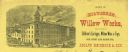
| Description: | Letterhead of the Milwaukee Willow Works, a manufacturer of children's carriages, willow ware, and toys, with a three-quarter view of the company building,... |
| Date: | 04 1884 |
|---|---|
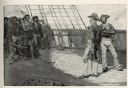
| Description: | An engraving depicting the impressment of American seamen by the British Navy during the period before the War of 1812. The image shows a group of American... |

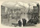
| Date: | 1873 |
|---|---|
| Description: | Engraved image of a lock and dam at Sault St. Marie. Two men are operating the sluice as ships are waiting on the opposite side of the lock. Another man is... |

| Date: | 1627 |
|---|---|
| Description: | Map of North and South America showing settlements, rivers, lakes, mountains, islands and regions of the western hemisphere. It includes an inset map of Gr... |

| Date: | 1630 |
|---|---|
| Description: | One of the few maps by Dutch cartographer Willem Blaeu depicting the Americas, this map shows regions, settlements, islands, mountains, forests, rivers, an... |

| Date: | 1684 |
|---|---|
| Description: | Map of North America showing some colonies, cities, rivers, lakes, and Native American land. Ship routes spread across both oceans, including one decorated... |

| Date: | 1713 |
|---|---|
| Description: | Map showing the regions explored by Robert de La Salle between 1681 and 1686, as well as the route La Salle, and later Henri Joutel, took, moving north fro... |

| Date: | 1770 |
|---|---|
| Description: | Map of North America from the Great Lakes to the northern portion of South America. It shows cities, Native American land, mountains, swamps, lakes, rivers... |

| Date: | 1759 |
|---|---|
| Description: | Map of north eastern Canada and parts of New England, showing settlements, cities, portages, Native American land, mountains, lakes, and rivers. The unusua... |

| Date: | 1755 |
|---|---|
| Description: | Map of Virginia and parts of Maryland, North Carolina, and New Jersey. It shows borders, boundary lines, some Native American land, counties, cities, towns... |
If you didn't find the material you searched for, our Library Reference Staff can help.
Call our reference desk at 608-264-6535 or email us at: