Filter: Categories of Wisconsin Historical Images
Filter: Subject of Engraving
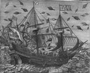
Filter: Subject of sailing ships
Filter: Categories of Wisconsin Historical Images
Filter: Subject of Engraving
Filter: Subject of sailing ships
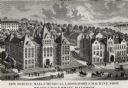
| Date: | 1887 |
|---|---|
| Description: | Engraving of an elevated view of Science Hall, Chemical Laboratory and Machine Shop on the University of Wisconsin-Madison campus. |
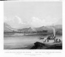
| Date: | 1832 |
|---|---|
| Description: | Camp of the Gros Ventres along the upper Missouri River, with white travelers passing by in a boat. |
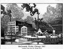
| Date: | 1867 |
|---|---|
| Description: | Engraving of the McCormick Reaper Works as it appeared in 1867. The factory was located on the north bank of the Chicago River, east of the Rush Street bri... |

| Date: | 1857 |
|---|---|
| Description: | Bird's-eye view of Madison over rooftop and across lake with sailboats and steamers. A group of people are standing on a viewing platform on the roof in th... |

| Date: | 1937 |
|---|---|
| Description: | Bird's-eye view of Milwaukee in 1853 details building features and city layout from southwest. Important buildings are numbered in a silhouette drawing bel... |

| Date: | 1655 |
|---|---|
| Description: | Map from Drake Expedition, ca. 1585. |

| Date: | 1655 |
|---|---|
| Description: | Map from Drake Expedition in Florida, ca. 1585. |

| Date: | 1856 |
|---|---|
| Description: | View along bridge of paddle boats and ships in the harbor, pedestrians, and the town in the background on the other side of the river. |

| Date: | 1856 |
|---|---|
| Description: | Receipt issued by the American Board of Commissioners of Foreign Missions to Frederick Smith for a contribution of ten cents from the Sabbath School of the... |

| Date: | 1930 |
|---|---|
| Description: | Color illustration of the Rush Street Bridge and Chicago River as it appeared in 1861. Includes the C.H. McCormick Reaper Works on the far side of the rive... |
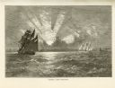
| Date: | 1874 |
|---|---|
| Description: | Engaved view depicting a dramatic sunset through clouds over Lake Michigan. Several sailing ships are in the foreground. |

| Date: | 1874 |
|---|---|
| Description: | Engraved view of downtown Racine seen from Lake Michigan. Several vessels are entering the harbor, and a pier with a beacon is on the right. |

| Date: | 1871 |
|---|---|
| Description: | Engraved view of Kenosha harbor. A group of men fish from a pier in the foreground while several boats float through the harbor. A tug is pulling a large s... |

| Date: | 1712 |
|---|---|
| Description: | Engraved double-hemispherical world map by Moll, included in his atlas The world described, or, A new and correct sett of maps: shewing the kingdoms and st... |

| Date: | 1785 |
|---|---|
| Description: | Map of part of North America engraved and hand-colored (the light brown design is a superposition of the map and cartouche derived from the oxidation of th... |
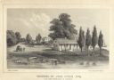
| Date: | 1856 |
|---|---|
| Description: | Lithograhic view of the residence of John Kinzie on the bank of the Chicago River at the mouth of Lake Michigan. The residence consists of a house with a f... |

| Date: | 1790 |
|---|---|
| Description: | This map of the north eastern states shows roads, rivers, lakes, waterfalls, mountains, cities, forts, mills, the Oneida Reservation, and "New York Donatio... |

| Date: | 1776 |
|---|---|
| Description: | Map of New Jersey and New York, showing cities, forts, roads, counties, townships, land grants, rivers, lakes and several topographical features. Much of t... |
If you didn't find the material you searched for, our Library Reference Staff can help.
Call our reference desk at 608-264-6535 or email us at: