 Filter: Categories of Wisconsin Historical Images
Filter: Subject of Engraving
Filter: Subject of rivers
Filter: Subject of officers
Filter: Categories of Wisconsin Historical Images
Filter: Subject of Engraving
Filter: Subject of rivers
Filter: Subject of officers
| Date: | |
|---|---|
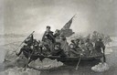
| Description: | Engraving of George Washington and his troops rowing across an icy Delaware River to attack the British, from the painting by E. Leutze. |

| Date: | 1755 |
|---|---|
| Description: | Map of New England, with three inset maps of Fort Oswego, Fort du Quesne, and Fort Frederick. It shows colonies, a few cities, forts (marked as French or E... |
If you didn't find the material you searched for, our Library Reference Staff can help.
Call our reference desk at 608-264-6535 or email us at: