Filter: Categories of Wisconsin Historical Images
Filter: Subject of Engraving
Filter: Subject of religion
Filter: Categories of Wisconsin Historical Images
Filter: Subject of Engraving
Filter: Subject of religion
| Date: | |
|---|---|
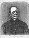
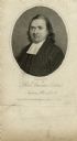
| Description: | Reverend P. Pernin made from a wood engraving from "The Finger Of God Is There." |

| Date: | 1832 |
|---|---|
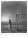
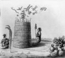
| Description: | Tombs made by Assiniboin Indians in trees. |

| Date: | 1655 |
|---|---|
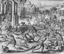
| Description: | Girolamo Benzoni (1519-1570) was an Italian from Milan who spent the years 1541-1556 in the New World. His observations of Spanish imperialism were publish... |
| Date: | 1655 |
|---|---|
| Description: | Girolamo Benzoni (1519-1570) was an Italian from Milan who spent the years 1541-1556 in the New World. His observations of Spanish imperialism were publish... |

| Date: | 1655 |
|---|---|
| Description: | Girolamo Benzoni (1519-1570) was an Italian from Milan who spent the years 1541-1556 in the New World. His observations of Spanish imperialism were publish... |
| Date: | 1880 |
|---|---|
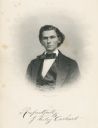
| Description: | Engraved portrait of J. Wesley Carhart of Racine, Methodist minister, physician, and inventor of a steam-powered automobile in 1871. Although impractical, ... |
| Date: | 06 24 1969 |
|---|---|
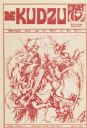
| Description: | Cover of "The Kudzu," an underground newspaper, featuring a reproduction of Martin Schongauer's 15th Century engraving entitled, "Saint Anthony Tormented b... |
| Date: | 1855 |
|---|---|
| Description: | An illustration of an Indian prophet standing by his lodge, which has symbols drawn on and floating above it. Others are seated, watching him. Two persons ... |

| Date: | 1856 |
|---|---|
| Description: | Receipt issued by the American Board of Commissioners of Foreign Missions to Frederick Smith for a contribution of ten cents from the Sabbath School of the... |
| Date: | 1808 |
|---|---|
| Description: | Engraved quarter-length portrait of Reverend Samson Occom. |
| Date: | 1892 |
|---|---|
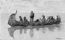
| Description: | Photographic print of an engraved image showing a robed missionary standing in a birch bark canoe paddled by four Native Americans and another man who appe... |
| Date: | |
|---|---|
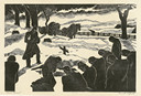
| Description: | Engraved view of a country burial in the snow. A clergyman reads a blessing as a mourner kneels near the grave. A group of mourners bow their heads. A team... |

| Date: | 1740 |
|---|---|
| Description: | Engraved and hand-colored map of the Iberian peninsula as a theater of war during the War of the Spanish Succession (1701-1714). The map is dedicated to Ki... |
| Date: | 1872 |
|---|---|
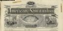
| Description: | Engraved masthead for The American Spiritualist depicting a seance over the word "phenomenal," a globe over the word "scientific," and a man at a de... |

| Date: | 1710 |
|---|---|
| Description: | A seminal and fairly accurate map of the Great Lakes Region up to Baffin's Bay in Northern Canada. This is possibly the first printed map to locate Detroit... |

| Date: | 1718 |
|---|---|
| Description: | This map shows the Mississippi River, with latitude and longitude coordinates, ad covers east to Lake Ontario and south to Illinois. The inset map (the top... |

| Date: | 1719 |
|---|---|
| Description: | Map of the Great Lakes and the St. Lawrence river showing French and English cities and villages, trading posts, Indian villages and tribes, portages, for... |

| Date: | 1795 |
|---|---|
| Description: | Map of Connecticut showing counties, townships, cities, roads, islands, swamps, hills, mountains, lakes, rivers, reefs, and numerous other geographical and... |

| Date: | 1760 |
|---|---|
| Description: | Map showing upstate New York, Lake Ontario, and the St. Lawrence River during the last, decisive battle of the French and Indian War. The main map shows a ... |
If you didn't find the material you searched for, our Library Reference Staff can help.
Call our reference desk at 608-264-6535 or email us at: