 Filter: Categories of Wisconsin Historical Images
Filter: Subject of Engraving
Filter: Subject of political science
Filter: Subject of cities and towns
Filter: Categories of Wisconsin Historical Images
Filter: Subject of Engraving
Filter: Subject of political science
Filter: Subject of cities and towns
| Date: | |
|---|---|
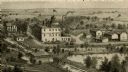
| Description: | An engraving based on a drawing by Alexander Simplot of the Platteville Brewery (spelled Plattville). It is an elevated perspective showing the main buildi... |
| Date: | 1854 |
|---|---|
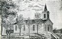
| Description: | Exterior view of a First Congregational Church. |

| Date: | 1885 |
|---|---|
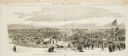
| Description: | Elevated view of the Park Hotel, with city traffic in the streets in the foreground. "'Park Hotel' South Corner Capitol Park." The reverse side gives a des... |
| Date: | 10 24 1863 |
|---|---|
| Description: | Panoramic wood-engraving of a cattle fair in New Haven, after a sketch by H.C. Curtis. Caption reads: "Cattle Show and Agricultural Faib [sic] at Ha... |

| Date: | 1870 |
|---|---|
| Description: | Magazine illustration of the home, titled: "Soldiers' National Asylum at Milwaukee, Wisconsin". The building is in the background, and in the foreground ar... |

| Date: | 1890 |
|---|---|
| Description: | Exterior of building, with arched main entrance. The road in front is crowded with pedestrians, trolleys, and horse-drawn vehicles. On the left is a boat ... |
| Date: | 1856 |
|---|---|
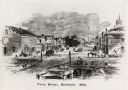
| Description: | View from bridge on river. Storefronts and homes line the road that stretches to the horizon. |
| Date: | |
|---|---|
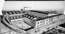
| Description: | Drawing showing the entire exterior of Pearl Button Company. |
| Date: | 1819 |
|---|---|
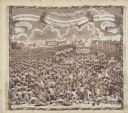
| Description: | A commemorative handkerchief created by a wood engraving on white cotton fabric. The scene is the Manchester Reform Meeting, in England. A crowd of demonst... |
| Date: | |
|---|---|
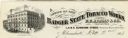
| Description: | Letterhead of the Badger State Tobacco Works of Milwaukee, Wisconsin, with a three-quarter view of the building, men working on boats moored near the water... |
| Date: | |
|---|---|
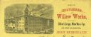
| Description: | Letterhead of the Milwaukee Willow Works, a manufacturer of children's carriages, willow ware, and toys, with a three-quarter view of the company building,... |
| Date: | |
|---|---|
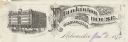
| Description: | Letterhead of Plankinton House in Milwaukee, Wisconsin, with a three-quarter view of the hotel and traffic in the street, including people on foot, on hors... |

| Date: | |
|---|---|
| Description: | Letterhead of the William Rahr Sons' Company of Manitowoc, Wisconsin, "Maltsters and Roasters," with an elevated view of the company building on one side o... |
| Date: | |
|---|---|
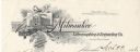
| Description: | Letterhead of the Milwaukee Lithographing & Engraving Company, with a three-quarter view of the building, set into a decorated border with the name of the ... |

| Date: | |
|---|---|
| Description: | Memohead of the Milwaukee Dry Dock Company, which operated two docks, with a view of a dock with ships, planks of wood, buildings, and the slogan, "Electri... |
| Date: | 1875 |
|---|---|
| Description: | Newspaper engraving of the building at Randolph and Dearborn Streets that served as the McCormick General Office from 1879 to 1885. An American flag flies ... |

| Date: | 1712 |
|---|---|
| Description: | Engraved double-hemispherical world map by Moll, included in his atlas The world described, or, A new and correct sett of maps: shewing the kingdoms and st... |

| Date: | 1715 |
|---|---|
| Description: | A map of the countries and islands surrounding the Gulf of Mexico. The hand-colored borders separate the territories of England, France, Spain, and Holland... |

| Date: | 1739 |
|---|---|
| Description: | This map shows the territorial claims of the western hemisphere by the European powers, as well as the names of major cities, geographical features, and pa... |

| Date: | 1720 |
|---|---|
| Description: | One of Herman Moll's most famous maps, often referred to as The Beaver Map for its elaborate engraved inset depicting and describing beavers building a dam... |
If you didn't find the material you searched for, our Library Reference Staff can help.
Call our reference desk at 608-264-6535 or email us at: