Filter: Categories of Wisconsin Historical Images
Filter: Subject of Engraving
Filter: Subject of land
Filter: Subject of recreation
Filter: Categories of Wisconsin Historical Images
Filter: Subject of Engraving
Filter: Subject of land
Filter: Subject of recreation
| Date: | 1832 |
|---|---|
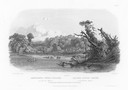
| Description: | Punka Indians encamped on the banks of the Missouri River and canoeing in river. |

| Date: | 1832 |
|---|---|
| Description: | Fort Clark, on the Missouri River, February 1834. |
| Date: | 1884 |
|---|---|
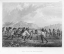
| Description: | Native Americans playing a lacrosse-like game of ball. |
| Date: | 1655 |
|---|---|
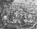
| Description: | Scene from near Jamestown Settlement, ca. 1620. |

| Date: | |
|---|---|
| Description: | Letterhead of the Kewaskum Mutual Fire Insurance Company of Washington County, Wisconsin, with a Native American man wearing buckskin clothes and leggings ... |
| Date: | 1884 |
|---|---|
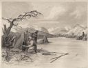
| Description: | Small group of Native Americans spearing fish through ice on a river. Mountains can be seen in the background. |
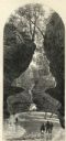
| Date: | 1874 |
|---|---|
| Description: | Engraved view of Rood's Glen. A boy plays with a toy boat at bottom left while two men and a woman talk at bottom right. Two other figures can be seen in t... |

| Date: | 03 06 1869 |
|---|---|
| Description: | Engraved image of a man in a top hat and tails riding a velocipede. Another rider is in the background. |

| Date: | 1877 |
|---|---|
| Description: | Engraving of the Peck Cabin, after the painting by Mrs. E.E. Bailey. Caption at bottom reads: "First House in Madison. 1837." |

| Date: | 1776 |
|---|---|
| Description: | Map of New Jersey and New York, showing cities, forts, roads, counties, townships, land grants, rivers, lakes and several topographical features. Much of t... |

| Date: | 1759 |
|---|---|
| Description: | Map of north eastern Canada and parts of New England, showing settlements, cities, portages, Native American land, mountains, lakes, and rivers. The unusua... |

| Date: | 1718 |
|---|---|
| Description: | Map of the Southern portion of North America from New Mexico to Florida and south from Lake Erie. It shows borders, cities, settlements, Native American la... |

| Date: | 1783 |
|---|---|
| Description: | Map of the newly formed United States showing borders, regions, Native American land, cities, mountains, lakes, and rivers. It includes a small inset map o... |

| Date: | 1720 |
|---|---|
| Description: | Detailed, ornate, and comprehensive map of America from the east coast to present day Texas. Numerous features appear throughout the map, including Native ... |

| Date: | 02 04 1783 |
|---|---|
| Description: | One of the first and few maps to attempt to map the new boundaries of the United States and British territories during the preliminary treaty at the end of... |
If you didn't find the material you searched for, our Library Reference Staff can help.
Call our reference desk at 608-264-6535 or email us at: