 Filter: Categories of Wisconsin Historical Images
Filter: Subject of Engraving
Filter: Subject of indians of north america
Filter: Subject of hunting
Filter: Categories of Wisconsin Historical Images
Filter: Subject of Engraving
Filter: Subject of indians of north america
Filter: Subject of hunting
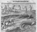
| Date: | 1655 |
|---|---|
| Description: | Engraving made after a painting by Jacques Le Moyne de Morgues (died 1588) while on the Laudonnière Expedition in Florida, ca. 1564. |
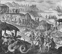
| Date: | 1655 |
|---|---|
| Description: | Scene near Jamestown Settlement in Virginia, ca. 1614. |
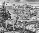
| Date: | 1655 |
|---|---|
| Description: | Scene from the Vespucci Expedition, 1499. |

| Date: | 1776 |
|---|---|
| Description: | Map of New Jersey and New York, showing cities, forts, roads, counties, townships, land grants, rivers, lakes and several topographical features. Much of t... |

| Date: | 1718 |
|---|---|
| Description: | Map of the Southern portion of North America from New Mexico to Florida and south from Lake Erie. It shows borders, cities, settlements, Native American la... |

| Date: | 1720 |
|---|---|
| Description: | Detailed, ornate, and comprehensive map of America from the east coast to present day Texas. Numerous features appear throughout the map, including Native ... |
If you didn't find the material you searched for, our Library Reference Staff can help.
Call our reference desk at 608-264-6535 or email us at: