 Filter: Categories of Wisconsin Historical Images
Filter: Subject of Engraving
Filter: Subject of human settlements
Filter: Subject of indians of north america
Filter: Categories of Wisconsin Historical Images
Filter: Subject of Engraving
Filter: Subject of human settlements
Filter: Subject of indians of north america
| Date: | 1832 |
|---|---|
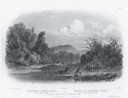
| Description: | Engraving of Indians on horseback along river with Indian grave on hill in background. |

| Date: | 1655 |
|---|---|
| Description: | Map of Virginia Coast based on observations by Captain John Smith. |
| Date: | 1655 |
|---|---|
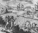
| Description: | Scene of the Jamestown Settlement in Virginia, ca. 1614 showing men at the water's edge being beckoned by mermaids. |
| Date: | 1655 |
|---|---|
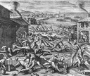
| Description: | Scene from Jamestown Settlement, 1622, purporting to show the massacre of 347 settlers by Openchancanough and his alliance of tribes in the Jamestown area. |

| Date: | 1837 |
|---|---|
| Description: | Fond du Lac Company House, built in 1836 and operated as an inn by Colwert Pier and his wife. Groups of Indians are in the yard outside the inn, and severa... |

| Date: | |
|---|---|
| Description: | Letterhead of the Kewaskum Mutual Fire Insurance Company of Washington County, Wisconsin, with a Native American man wearing buckskin clothes and leggings ... |

| Date: | 1877 |
|---|---|
| Description: | Engraving of the Peck Cabin, after the painting by Mrs. E.E. Bailey. Caption at bottom reads: "First House in Madison. 1837." |

| Date: | 1721 |
|---|---|
| Description: | A map of North and South America with an elaborately illustrated cartouche depicting Native Americans in upper left corner. The map is fairly detailed, dep... |

| Date: | 1720 |
|---|---|
| Description: | One of Herman Moll's most famous maps, often referred to as The Beaver Map for its elaborate engraved inset depicting and describing beavers building a dam... |

| Date: | 1718 |
|---|---|
| Description: | This map shows the Mississippi River, with latitude and longitude coordinates, ad covers east to Lake Ontario and south to Illinois. The inset map (the top... |

| Date: | 1719 |
|---|---|
| Description: | Map of the British colonies and territories in North American, depicting cities, Native American land, rivers, mines, forts, trees, and topography east of ... |

| Date: | 1720 |
|---|---|
| Description: | This map of North America shows cities, rivers, lakes, and a few topographical features, complete with numerous descriptive blocks of text about expedition... |

| Date: | 1750 |
|---|---|
| Description: | Map of the northeast corner of America and Canada with hand-colored boundaries. The map shows colonies, Native American nations, fishing areas, and detaile... |

| Date: | 1746 |
|---|---|
| Description: | Map of North America from the southern portion of James Bay to Florida. It shows the colonies, cities, Native American land, and topological and geographic... |

| Date: | 1780 |
|---|---|
| Description: | This map shows the northern Pacific Ocean with North America and Asia, with cities and geographical features labeled, as well Russian, French and Spanish r... |

| Date: | 1758 |
|---|---|
| Description: | This map of the north-west hemisphere shows the cities, lakes, rivers, mountains, and political borders. In the upper left corner sits a decorative cartouc... |

| Date: | 1755 |
|---|---|
| Description: | This map shows forts, missions, villages and cities, rivers and portages, and boundaries of the Spanish, English, and French territories, marking the large... |

| Date: | 1757 |
|---|---|
| Description: | This map shows the cities, plantations, lakes, rivers, mountains, Native American territories and colonial borders of the Eastern half of North America, pl... |

| Date: | 1755 |
|---|---|
| Description: | This map shows the eastern half of North America during the French and Indian war, including cities, borders, Native American Land, forts, and detailed geo... |

| Date: | 1782 |
|---|---|
| Description: | Map of the West Indies and south eastern North America, remarkably detailed, showing cities, mountains, rivers, lakes, mines, plantations, forts, banks, an... |
If you didn't find the material you searched for, our Library Reference Staff can help.
Call our reference desk at 608-264-6535 or email us at: