Filter: Categories of Wisconsin Historical Images
Filter: Subject of Engraving
Filter: Subject of hills
Filter: Subject of transportation
Filter: Categories of Wisconsin Historical Images
Filter: Subject of Engraving
Filter: Subject of hills
Filter: Subject of transportation

| Date: | 1821 |
|---|---|
| Description: | Engraving depicting the Schoolcraft expedition crossing the Ontonagon River to investigate a copper boulder. |

| Date: | 1850 |
|---|---|
| Description: | Travelers in a rowing canoe on Lake Superior. |

| Date: | 1784 |
|---|---|
| Description: | Plate 57. Scene from Cook's Third Expedition, 1776-1779, while in Alaska. |
| Date: | |
|---|---|
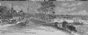
| Description: | An engraving based on a drawing by Alexander Simplot. The image shows a very detailed aerial view of a hillside with a tramway traversing the side. There a... |
| Date: | |
|---|---|
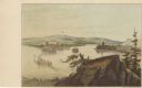
| Description: | Drawing of the mouth of the Wisconsin River from a scenic overlook depicting a steamboat in the distance. Print is part of a series collected in Lewis' "Da... |

| Date: | |
|---|---|
| Description: | Letterhead of the Kewaskum Mutual Fire Insurance Company of Washington County, Wisconsin, with a Native American man wearing buckskin clothes and leggings ... |
| Date: | 1874 |
|---|---|
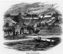
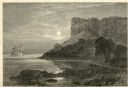
| Description: | Engraved view of Maiden's Rock at Lake Pepin. A steamboat is on the Mississippi River. |

| Date: | 03 06 1869 |
|---|---|
| Description: | Engraved image of a man in a top hat and tails riding a velocipede. Another rider is in the background. |
| Date: | 1810 |
|---|---|
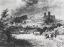
| Description: | View of the city of Lincoln, England. Photocopy after an engraving by B.G. Topham. |

| Date: | |
|---|---|
| Description: | Engraved print of a man riding atop a wagonload of hay pulled by a horse along a road in a hilly rural area. On the left is a barn and silos. |
| Date: | 1880 |
|---|---|
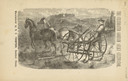
| Description: | Front page of booklet with an engraving of a man with a team of two horses in a field with the "Celebrated Gorham Sulky Cultivator." |

| Date: | 1776 |
|---|---|
| Description: | Map of New Jersey and New York, showing cities, forts, roads, counties, townships, land grants, rivers, lakes and several topographical features. Much of t... |

| Date: | 1755 |
|---|---|
| Description: | Map of the northeastern portion of America and Canada, east of the Hudson River and south from Labrador. It names regions, colonies, cities, numerous forts... |

| Date: | 1767 |
|---|---|
| Description: | Map of the north east coast of America, showing colonial borders, cities, Native American land, lakes, rivers, and a few hills and mountains. Illustrated t... |

| Date: | 1795 |
|---|---|
| Description: | Map of Maine, showing a few cities, harbors, hills, mountains, lakes, and rivers. A road runs from Pownalboro south to Portsmouth harbor, and the boundary ... |

| Date: | 1795 |
|---|---|
| Description: | Map of Massachusetts showing counties, cities, roads, islands (including Nantucket and Martha's Vineyard), mountains, hills, lakes, and rivers. Two small e... |

| Date: | 1795 |
|---|---|
| Description: | Map of Connecticut showing counties, townships, cities, roads, islands, swamps, hills, mountains, lakes, rivers, reefs, and numerous other geographical and... |
If you didn't find the material you searched for, our Library Reference Staff can help.
Call our reference desk at 608-264-6535 or email us at: