 Filter: Categories of Wisconsin Historical Images
Filter: Subject of Engraving
Filter: Subject of fields (agriculture)
Filter: Categories of Wisconsin Historical Images
Filter: Subject of Engraving
Filter: Subject of fields (agriculture)
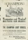
| Date: | 1882 |
|---|---|
| Description: | Advertising handbill for the Champion harvester and binder. Includes the text: "the Champion light binder, is the only simple, light, durable, efficient wo... |
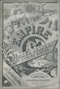
| Date: | 1884 |
|---|---|
| Description: | Cover of an advertising catalog for J.F. Seiberling, manufacturer of agricultural equipment, featuring an engraving of boys marching under a benner of "Vic... |
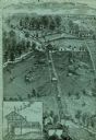
| Date: | |
|---|---|
| Description: | An engraving based on a drawing by Alexander Simplot. The image shows a very detailed aerial view of a hillside with a tramway traversing the side. There a... |
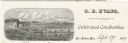
| Date: | |
|---|---|
| Description: | Letterhead of G.E. Evans, a grower of cultivated cranberries from New Lisbon, Wisconsin. Includes an illustration by (A.?) R.R. Richards of people working ... |
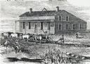
| Date: | 1840 |
|---|---|
| Description: | Sod-breaker and five yoke of oxen plowing in front of the “Old Cottage Inn.” In the foreground a boat is on the shoreline. |
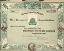
| Date: | |
|---|---|
| Description: | Wisconsin State Bee Keepers Association membership certificate, signed by N.E. France Association President. No. 148. Illustrations of clover flowers and b... |

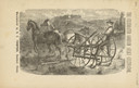
| Date: | |
|---|---|
| Description: | Engraved print of a man riding atop a wagonload of hay pulled by a horse along a road in a hilly rural area. On the left is a barn and silos. |
| Date: | 1880 |
|---|---|
| Description: | Front page of booklet with an engraving of a man with a team of two horses in a field with the "Celebrated Gorham Sulky Cultivator." |
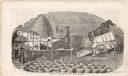
| Date: | 1850 |
|---|---|
| Description: | Engraving of a man in a coat and hat feeding stalks into a thresher. The thresher is run by two horses on a treadmill at right. The grain is collected from... |

| Date: | 03 1777 |
|---|---|
| Description: | Map showing the British and Hessian attack on Fort Washington in November of 1776. The movements and fortifications of the British and Hessian troops appea... |

| Date: | 1776 |
|---|---|
| Description: | Fairly detailed map of New York City and parts of Long Island. It shows streets, roads, wharves, ferries, ship yards, Fort George and the battery, public b... |
If you didn't find the material you searched for, our Library Reference Staff can help.
Call our reference desk at 608-264-6535 or email us at: