Filter: Categories of Wisconsin Historical Images
Filter: Subject of Engraving
Filter: Subject of dogs
Filter: Categories of Wisconsin Historical Images
Filter: Subject of Engraving
Filter: Subject of dogs
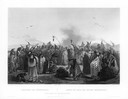
| Date: | 1832 |
|---|---|
| Description: | Funeral of a Sioux Chief near Fort Pierre. |
| Date: | 1832 |
|---|---|
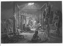
| Description: | Interior of the hut of a Mandan chief showing various objects and animals with five Mandans seated on ground. |
| Date: | 1832 |
|---|---|
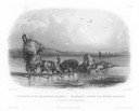
| Description: | Two dog-sledges hauling supplies, with one also carrying a Mandan. |
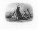
| Date: | 1832 |
|---|---|
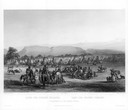
| Description: | Minatarre scalp dance ceremonial gathering. |
| Date: | 1832 |
|---|---|
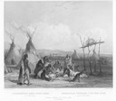
| Description: | A skin lodge of an Assiniboin Chief. The engraving includes a man on horseback and a dog harnessed to a travois. |

| Date: | 1870 |
|---|---|
| Description: | Magazine illustration of the home, titled: "Soldiers' National Asylum at Milwaukee, Wisconsin". The building is in the background, and in the foreground ar... |
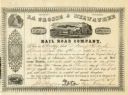
| Date: | 1857 |
|---|---|
| Description: | Engraved document certifying that D. Henry Rockwell of Oconomowoc is entitled to one share of the La Crosse and Milwaukee Rail Road Company worth one hundr... |

| Date: | 1718 |
|---|---|
| Description: | This map shows the Mississippi River, with latitude and longitude coordinates, ad covers east to Lake Ontario and south to Illinois. The inset map (the top... |

| Date: | 1746 |
|---|---|
| Description: | This world map from the German mathematician, historian, and geographer Johann Matthias Hase shows the major cities, islands, and the major political divis... |

| Date: | 1636 |
|---|---|
| Description: | Map of North America, divided into regions, and showing some rivers, lakes, settlements, cities, mountains, and Native American land. Of the Great Lakes on... |
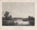
| Date: | 1858 |
|---|---|
| Description: | Engraved print of four men and a dog in a boat on Lake Winnebago. Two of the men are in the center of the boat holding hunting rifles, while one man is sta... |
If you didn't find the material you searched for, our Library Reference Staff can help.
Call our reference desk at 608-264-6535 or email us at: