Filter: Categories of Wisconsin Historical Images
Filter: Subject of Engraving
Filter: Subject of church buildings
Filter: Categories of Wisconsin Historical Images
Filter: Subject of Engraving
Filter: Subject of church buildings
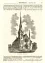
| Date: | 1871 |
|---|---|
| Description: | Wood engraving of the Congregationalist Church in Peshtigo. From the book "Sketch Of The Great Fires In Wisconsin". |
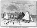
| Date: | 03 09 1878 |
|---|---|
| Description: | Illustration by N.A. Greenback of ice-skaters and iceboats featuring the new Poughkeepsie design of pivoting runners. A key at the bottom of the image iden... |
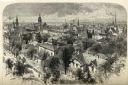
| Date: | 1874 |
|---|---|
| Description: | Bird's-eye view of Milwaukee looking southwest toward the county courthouse under construction in the public square west of St. John's Cathedral. |

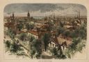
| Date: | 1937 |
|---|---|
| Description: | Bird's-eye view of Milwaukee in 1853 details building features and city layout from southwest. Important buildings are numbered in a silhouette drawing bel... |
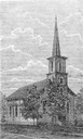
| Date: | 06 26 1869 |
|---|---|
| Description: | An engraving from the Billed-Magazine of the First Congregational Church. |
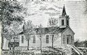
| Date: | 1854 |
|---|---|
| Description: | Exterior view of a First Congregational Church. |

| Date: | 1910 |
|---|---|
| Description: | View of St. John's Evangelical Church in Monroe. |
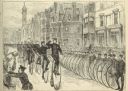
| Date: | 05 30 1881 |
|---|---|
| Description: | Engraving of a sketch by Joseph Pennell showing a parade of League of American Wheelmen bicyclists along Commonwealth Avenue between Dartmouth Street and W... |
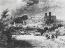
| Date: | 1810 |
|---|---|
| Description: | View of the city of Lincoln, England. Photocopy after an engraving by B.G. Topham. |

| Date: | 1795 |
|---|---|
| Description: | Map of Connecticut showing counties, townships, cities, roads, islands, swamps, hills, mountains, lakes, rivers, reefs, and numerous other geographical and... |

| Date: | 1760 |
|---|---|
| Description: | Map showing upstate New York, Lake Ontario, and the St. Lawrence River during the last, decisive battle of the French and Indian War. The main map shows a ... |

| Date: | 1789 |
|---|---|
| Description: | Map of New York City showing ward boundaries, ferries, streets, roads, swamps, ponds, and rivers. The properties of Lispinard, Byards, Jones, Rutgers, and ... |

| Date: | 1779 |
|---|---|
| Description: | Map of North Carolina showing counties, cities, towns, chapels, courthouses, Quaker meeting houses, forts, mountains, swamps, inlets, lakes, and rivers. A ... |

| Date: | 1761 |
|---|---|
| Description: | Map of New Orleans with north oriented towards the upper right corner. It shows the land around the city, the Mississippi River, anchorages, roads leading ... |
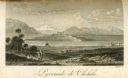
| Date: | 1816 |
|---|---|
| Description: | The four-stepped, low-rising Pyramid of Cholula, covered in sparse vegetation, stands in a flat valley, surrounded by distant mountains. A stairway leads u... |
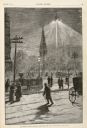
| Date: | 01 14 1882 |
|---|---|
| Description: | A drawing showing Madison Square at night, lit by electric lighting at the top of a mast. Men and women are strolling on the sidewalks and walking on the s... |
If you didn't find the material you searched for, our Library Reference Staff can help.
Call our reference desk at 608-264-6535 or email us at: