 Filter: Categories of Wisconsin Historical Images
Filter: Subject of Engraving
Filter: Subject of children and adults
Filter: Categories of Wisconsin Historical Images
Filter: Subject of Engraving
Filter: Subject of children and adults

| Date: | 1871 |
|---|---|
| Description: | Photographic print of a wood engraving of a schoolhouse and children in Peshtigo. From the book "Sketch of the Great Fire In Peshtigo." |

| Date: | |
|---|---|
| Description: | Engraving from a photograph of Ulysses S. Grant with his family. |
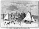
| Date: | 03 09 1878 |
|---|---|
| Description: | Illustration by N.A. Greenback of ice-skaters and iceboats featuring the new Poughkeepsie design of pivoting runners. A key at the bottom of the image iden... |
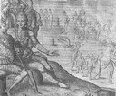
| Date: | 1655 |
|---|---|
| Description: | Engraving made after a painting by Jacques Le Moyne de Morgues (died 1588) while on the Laudonnière Expedition in Florida, ca. 1564. |

| Date: | 1850 |
|---|---|
| Description: | An engraving depicting a formally dressed family gathered around a Christmas tree, which is lit with candles. |

| Date: | |
|---|---|
| Description: | Engraving of Connecticut Hall, Yale's first permanent building, completed in 1752. The engraving shows a front view of the original Yale building, and a fe... |
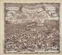
| Date: | 1819 |
|---|---|
| Description: | A commemorative handkerchief created by a wood engraving on white cotton fabric. The scene is the Manchester Reform Meeting, in England. A crowd of demonst... |
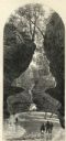
| Date: | 1874 |
|---|---|
| Description: | Engraved view of Rood's Glen. A boy plays with a toy boat at bottom left while two men and a woman talk at bottom right. Two other figures can be seen in t... |

| Date: | 1630 |
|---|---|
| Description: | One of the few maps by Dutch cartographer Willem Blaeu depicting the Americas, this map shows regions, settlements, islands, mountains, forests, rivers, an... |

| Date: | 1683 |
|---|---|
| Description: | Map of the north east coast of North America showing islands, regions, Native American land, bays, and a few European settlements. The Great Lakes appear i... |

| Date: | 1710 |
|---|---|
| Description: | Map of North America showing the European claims, Native American land and villages, rivers, lakes, cities, and notes on explorers, discoveries, and topogr... |

| Date: | 1719 |
|---|---|
| Description: | Map of North America showing land divisions between France, Spain, England, Sweden, Denmark and Holland. The map is detailed, labeling cities, forts, islan... |

| Date: | 1733 |
|---|---|
| Description: | This map of North America shows settlements, rivers, lakes, Native American land, trade winds, and numerous topographical features such as forests and moun... |
If you didn't find the material you searched for, our Library Reference Staff can help.
Call our reference desk at 608-264-6535 or email us at: