 Filter: Categories of Wisconsin Historical Images
Filter: Subject of Engraving
Filter: Subject of botany
Filter: Subject of birds
Filter: Categories of Wisconsin Historical Images
Filter: Subject of Engraving
Filter: Subject of botany
Filter: Subject of birds
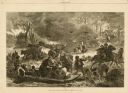
| Date: | 11 25 1871 |
|---|---|
| Description: | Engraved view of Peshtigo Fire showing people trying to escape the flames by boat and on horseback. A team of cattle also seek refuge and several birds tak... |
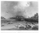
| Date: | 1832 |
|---|---|
| Description: | Steamboat navigating through sunken trees on the Missouri River. |

| Date: | 1832 |
|---|---|
| Description: | Junction of the Yellowstone River and the Missouri River. |
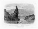
| Date: | 1832 |
|---|---|
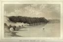
| Description: | The Citadel Rock on the Upper Missouri River. |

| Date: | 1655 |
|---|---|
| Description: | Frontispiece to Newe Welt vnd americanische Historien (1655). |

| Date: | 1870 |
|---|---|
| Description: | Magazine illustration of the home, titled: "Soldiers' National Asylum at Milwaukee, Wisconsin". The building is in the background, and in the foreground ar... |

| Date: | 01 1852 |
|---|---|
| Description: | A colored engraving depicting a bird under a glass dome with flowers and plants on a decorative shelf. |
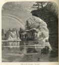
| Date: | |
|---|---|
| Description: | Engraved view of "The Jaws" in the Wisconsin Dells. |

| Date: | 1886 |
|---|---|
| Description: | Engraved image from a sketch by Theodore Davis showing four men bicycling. |
| Date: | 1856 |
|---|---|
| Description: | Lithographic view of a man in a canoe on Big-Foot's Lake (modern day Lake Geneva) with a small settlement on a bluff overlooking the lake. A group of birds... |

| Date: | 1746 |
|---|---|
| Description: | Detailed map of the western hemisphere and part of Africa and Europe. Islands, cities, settlements, rivers, lakes, countries, and regions are marked. Mount... |

| Date: | 1758 |
|---|---|
| Description: | Map showing lakes, rivers, cities, Native American land, and the boundaries of French and English claims in America and Canada north of New York. A title c... |

| Date: | 1720 |
|---|---|
| Description: | Detailed, ornate, and comprehensive map of America from the east coast to present day Texas. Numerous features appear throughout the map, including Native ... |
If you didn't find the material you searched for, our Library Reference Staff can help.
Call our reference desk at 608-264-6535 or email us at:
