Filter: Categories of Wisconsin Historical Images
Filter: Subject of Engraving
Filter: Subject of boats and boating
Filter: Categories of Wisconsin Historical Images
Filter: Subject of Engraving
Filter: Subject of boats and boating
| Date: | |
|---|---|
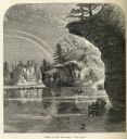
| Description: | Engraved view of "The Jaws" in the Wisconsin Dells. |

| Date: | 1871 |
|---|---|
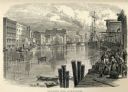
| Description: | Engraved view of Kenosha harbor. A group of men fish from a pier in the foreground while several boats float through the harbor. A tug is pulling a large s... |
| Date: | 1825 |
|---|---|
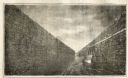
| Description: | Engraved view of boats being towed by horses through the Erie Canal at Lockport Erie Canal at Lockport. The horses can be seen on a high towpath at right. ... |

| Date: | |
|---|---|
| Description: | A scene including the American Fur Company buildings, an American flag, a lake and people in boats. |
| Date: | 1840 |
|---|---|
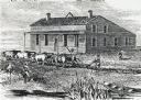
| Description: | Sod-breaker and five yoke of oxen plowing in front of the “Old Cottage Inn.” In the foreground a boat is on the shoreline. |

| Date: | 1740 |
|---|---|
| Description: | Engraved and hand-colored map of the Iberian peninsula as a theater of war during the War of the Spanish Succession (1701-1714). The map is dedicated to Ki... |

| Date: | 1785 |
|---|---|
| Description: | Map of part of North America engraved and hand-colored (the light brown design is a superposition of the map and cartouche derived from the oxidation of th... |

| Date: | 1770 |
|---|---|
| Description: | Map of North America from the Great Lakes to the northern portion of South America. It shows cities, Native American land, mountains, swamps, lakes, rivers... |

| Date: | 1755 |
|---|---|
| Description: | Map of the northeastern portion of America and Canada, east of the Hudson River and south from Labrador. It names regions, colonies, cities, numerous forts... |
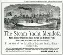
| Date: | 1890 |
|---|---|
| Description: | Advertisement for The Steam Yacht "Mendota." At the top is an engraving of the steam yacht under way loaded with passengers, and below is text. Some of the... |
| Date: | 1858 |
|---|---|
| Description: | Engraved print of four men and a dog in a boat on Lake Winnebago. Two of the men are in the center of the boat holding hunting rifles, while one man is sta... |
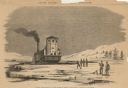
| Date: | 1859 |
|---|---|
| Description: | Engraved drawing of Norman Wiard's ice locomotive, the Lady Franklin operating on a frozen river. Male passengers and crew members are standing on t... |
| Date: | 1859 |
|---|---|
| Description: | Engraved drawing of Norman Wiard's ice locomotive, Lady Franklin being pulled from water onto ice using its anchor. The vessel was built, but never ... |
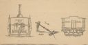
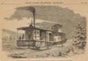
| Date: | 1859 |
|---|---|
| Description: | Cutaway details of Norman Wiard's ice locomotive, Lady Franklin sowing the stern and seating area. Also included is a drawing of the vehicle's ancho... |
If you didn't find the material you searched for, our Library Reference Staff can help.
Call our reference desk at 608-264-6535 or email us at: