 Filter: Categories of Wisconsin Historical Images
Filter: Subject of Engraving
Filter: Subject of arts
Filter: Subject of land
Filter: Categories of Wisconsin Historical Images
Filter: Subject of Engraving
Filter: Subject of arts
Filter: Subject of land

| Date: | 1850 |
|---|---|
| Description: | Travelers in a rowing canoe on Lake Superior. |
| Date: | 1832 |
|---|---|
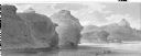
| Description: | Remarkable hills on the Upper Missouri River (view 1). |
| Date: | 1832 |
|---|---|
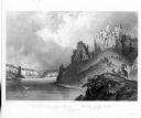
| Description: | View of the Stone Walls on the Upper Missouri River. Includes herd of bighorn sheep. |
| Date: | 1832 |
|---|---|
| Description: | Herd of Bison, on the Upper Missouri River. |
| Date: | 1655 |
|---|---|
| Description: | Scene from the Laudonnière Expedition in South Carolina, ca. 1564. |
| Date: | 1878 |
|---|---|
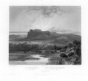
| Description: | Engraving of Ocatagon House, the residence of Mrs. Eliza Richards. Several trees dot the landscape and other buildings can be seen in the distance at right... |

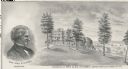
| Date: | 1877 |
|---|---|
| Description: | Engraving of the Peck Cabin, after the painting by Mrs. E.E. Bailey. Caption at bottom reads: "First House in Madison. 1837." |

| Date: | 1783 |
|---|---|
| Description: | This map is hand-colored and shows the boundaries of British, Spanish, and the newly recognized American claims, as well as the fishing rights granted to F... |

| Date: | 1709 |
|---|---|
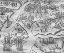
| Description: | Map of North America, showing a few of the largest settlements, regions, islands, and a few rivers. The Great Lakes are depicted, but over-sized, and Calif... |

| Date: | 02 04 1783 |
|---|---|
| Description: | One of the first and few maps to attempt to map the new boundaries of the United States and British territories during the preliminary treaty at the end of... |

| Date: | 1780 |
|---|---|
| Description: | Detailed topographical and political map of the area from Lake Champlain to Albany and the Hudson River. Relief is shown through hachures. The map shows ci... |
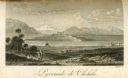
| Date: | 1816 |
|---|---|
| Description: | The four-stepped, low-rising Pyramid of Cholula, covered in sparse vegetation, stands in a flat valley, surrounded by distant mountains. A stairway leads u... |
If you didn't find the material you searched for, our Library Reference Staff can help.
Call our reference desk at 608-264-6535 or email us at: