 Filter: Categories of Wisconsin Historical Images
Filter: Subject of Engraving
Filter: Subject of arts
Filter: Type of Map or Atlas
Filter: Categories of Wisconsin Historical Images
Filter: Subject of Engraving
Filter: Subject of arts
Filter: Type of Map or Atlas

| Date: | 1885 |
|---|---|
| Description: | Mining and lumbering provided the impetus for the development of northern Wisconsin and Ashland was ideally situated to become a leading city of the "new W... |

| Date: | 1906 |
|---|---|
| Description: | Bird's-eye map of South Milwaukee. |

| Date: | 1655 |
|---|---|
| Description: | Map of Virginia Coast based on observations by Captain John Smith. |

| Date: | 1655 |
|---|---|
| Description: | Map from Drake Expedition, ca. 1585. |

| Date: | 1655 |
|---|---|
| Description: | Map from Drake Expedition in Florida, ca. 1585. |
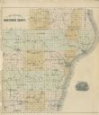
| Date: | 1878 |
|---|---|
| Description: | Outline map of Manitowoc County. Includes engraving of Wisconsin State Seal at bottom right. |

| Date: | 1820 |
|---|---|
| Description: | Map of the Northwestern Territories of the United State showing the track pursued by the Expedition in 1820. |

| Date: | 1695 |
|---|---|
| Description: | Copperplate engraving; Venice, 1695. Scale [ca. 1:5,069,000] at center. |

| Date: | 1698 |
|---|---|
| Description: | Copperplate engraving. Scale [ca. 1:11,500,00]. |

| Date: | 1688 |
|---|---|
| Description: | This map includes vignettes of Amerindian life with text describing geography, culture, and exploration activity, written in French. The Great Lakes, river... |

| Date: | 1831 |
|---|---|
| Description: | Map of the city of Louisville, Kentucky on the Ohio River showing streets and numbered lots. The Ohio River, Corn Island, and the Louisville and Portland C... |

| Date: | 1720 |
|---|---|
| Description: | Double hemispherical world map showing routes of Tasman, Magellan, Mendana, etc. Relief shown pictorially. Title in oak wreath cartouche. Map between four ... |

| Date: | 1712 |
|---|---|
| Description: | Engraved double-hemispherical world map by Moll, included in his atlas The world described, or, A new and correct sett of maps: shewing the kingdoms and st... |

| Date: | 1696 |
|---|---|
| Description: | Engraved and hand-colored map of Ethiopia, from Blaeu's General Atlas. Map title is framed by a man and a woman, both wearing head turbans, who are standin... |

| Date: | 1798 |
|---|---|
| Description: | Engraved and hand-colored map of Egypt. Map title appears on bottom left as a carving in stone next ... |

| Date: | 1740 |
|---|---|
| Description: | Engraved and hand-colored map of the Iberian peninsula as a theater of war during the War of the Spanish Succession (1701-1714). The map is dedicated to Ki... |

| Date: | 1785 |
|---|---|
| Description: | Map of part of North America engraved and hand-colored (the light brown design is a superposition of the map and cartouche derived from the oxidation of th... |

| Date: | 1760 |
|---|---|
| Description: | A map of the world in two hemispheres, with the borders of the continents hand-colored. This map contains 14 spherical diagrams of the cosmos, portraying t... |

| Date: | 1715 |
|---|---|
| Description: | A map of the countries and islands surrounding the Gulf of Mexico. The hand-colored borders separate the territories of England, France, Spain, and Holland... |
If you didn't find the material you searched for, our Library Reference Staff can help.
Call our reference desk at 608-264-6535 or email us at:
