 Filter: Categories of Wisconsin Historical Images
Filter: Subject of Economics
Filter: County of Jefferson
Filter: Categories of Wisconsin Historical Images
Filter: Subject of Economics
Filter: County of Jefferson
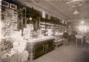
| Date: | 1909 |
|---|---|
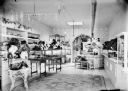
| Description: | Colorful advertising displays line the counters of this turn-of-the- century drugstore, with rows of glass pharmaceutical bottles filling the shelves behin... |

| Date: | |
|---|---|
| Description: | View of the businesses on Union Street, notably J.P. Dennett's Drug Store, located on the far right corner. |
| Date: | |
|---|---|
| Description: | Exterior view of Iverson's Pharmacy and Hayes Restaurant. |
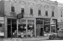
| Date: | 03 16 1939 |
|---|---|
| Description: | Fort Atkinson street scene, looking across street towards a truck parked in front of Beckman's Shoe Store. Next to Beckman's is Fort Furniture Mart and For... |
| Date: | 1879 |
|---|---|
| Description: | View of main street in Lake Mills. On the left of the image are the Fargo and Ostrander store, Farmer's Cash Store and Drugs, and A.J. Foster Harness Shop.... |

| Date: | 1915 |
|---|---|
| Description: | Exterior view of the state bank and city hall. Caption reads: "City Hall & Bank, Rome Wis." |
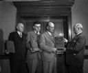
| Date: | 01 27 1947 |
|---|---|
| Description: | R.E. Gess, district engineer with Employers Mutual Insurance Company, presenting safety awards to three employees of James Manufacturing Company, Fort Atki... |
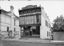
| Date: | |
|---|---|
| Description: | View from street of Wilkowski Brothers Manufacturers of Cigars storefront, with signage at top of building. A number of circus posters are on a large wall ... |
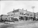
| Date: | |
|---|---|
| Description: | View from Third and Main Street of storefronts. There is signage for the Tetzlaff and Co. Building Materials above a pile of bricks in a sideyard near the ... |

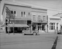
| Date: | 07 21 1962 |
|---|---|
| Description: | A parking lot underneath a newly developed block of stores. The Rock River is visible just beyond the parking lot. There is a bridge in the background. |
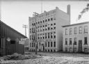
| Date: | |
|---|---|
| Description: | View from road of facade of the company building of the Brand Automatic Cashier. A shed on the left has advertisements for: "Bull Durham for Pipe or Cigare... |
| Date: | |
|---|---|
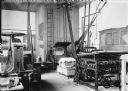
| Description: | Interior of print shop. The machinery, including printing presses, are belt-driven. The belts are driven by machines attached to the top of the high ceilin... |
| Date: | |
|---|---|
| Description: | Interior of hat shop illuminated by skylight. |
| Date: | |
|---|---|
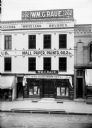
| Description: | View from across street of storefront of Wm. C. Raue. at 202 Main Street. Signs on the building say: "Wallpaper, Paints, Oils." |
| Date: | 1909 |
|---|---|
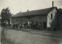
| Description: | Men with horses and wagons gathered outside the Faville Grove Farmers' Co-Operative Cheese Factory. A poster advertising the State Fair is pasted to the wa... |

| Date: | 05 01 1957 |
|---|---|
| Description: | Mrs. Norman Gill is standing and looking out of a window from inside her home at Spring Hill Farm near Cambridge, viewing the surrounding countryside and t... |

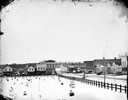
| Date: | 1870 |
|---|---|
| Description: | Bird’s-eye view map. "Looking north east." Indexed for points of interest. Shows homes, businesses, and the Bark and Rock River. Streets running west to ea... |

| Date: | 1976 |
|---|---|
| Description: | Includes index of streets and of local businesses. Shows location of Citizens State Bank, roads, highways, railroads, parks, cemeteries, and city sanitary ... |

| Date: | 1872 |
|---|---|
| Description: | Map shows townships and sections, landownership, roads, railroads, churches, schools, and cemeteries. The map includes business directories of Watertown, J... |

| Date: | 1940 |
|---|---|
| Description: | This map of Aztalan is pencil and ink on paper. The map shows streets, local businesses, churches, houses, and the Crawfish River. The map reads: "Informat... |
If you didn't find the material you searched for, our Library Reference Staff can help.
Call our reference desk at 608-264-6535 or email us at: