 Filter: Categories of Wisconsin Historical Images
Filter: Subject of Economics
Filter: County of Columbia
Filter: Subject of transportation
Filter: Categories of Wisconsin Historical Images
Filter: Subject of Economics
Filter: County of Columbia
Filter: Subject of transportation
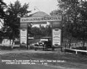
| Date: | 07 1927 |
|---|---|
| Description: | Car parked underneath the entrance gate to the Island Resort at the Wisconsin Dells, 25 miles from the Dells on Highway 12-16 near Mauston. Entrance gate a... |

| Date: | 09 11 1931 |
|---|---|
| Description: | Crowd standing on the street and sidewalk in front of the Doylestown Bank after a robbery. |
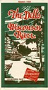
| Date: | 1928 |
|---|---|
| Description: | "The Dells," a brochure issued by the Chicago, Milwaukee & St. Paul and Pacific Railroad to advertise the Wisconsin Dells, a destination only five hours fr... |
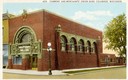
| Date: | 1930 |
|---|---|
| Description: | Farmers' and Merchants' Union Bank on a street corner. Designed by Louis Sullivan. Caption reads: "Farmers' and Merchants' Union Bank, Columbus, Wisconsin.... |
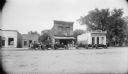
| Date: | |
|---|---|
| Description: | Street scene featuring the Ford Garage and the Bowman Bank. Several cars are parked in front of the buildings. |
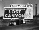
| Date: | |
|---|---|
| Description: | Sign for Lost Canyon, with people standing near a car in the foreground. |

| Date: | 1928 |
|---|---|
| Description: | Man pumps gas into an automobile at the Consolidated Boat Co. There is advertising for Coca-Cola, Baby Ruth, and Occident Flour on the side of the small fr... |
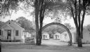
| Date: | 1950 |
|---|---|
| Description: | Entrance sign and rainbow between two trees in front of several cabins at the Rainbow Cabins. The cabins were located on Route 16 on Vine Street. |

| Date: | |
|---|---|
| Description: | Night view of gift shops, restaurants, and other attractions in a two-story shopping plaza. Several cars are parked along the curb beneath a streetlight in... |
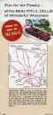
| Date: | |
|---|---|
| Description: | Back fold of a Wisconsin Dells promotional brochure featuring a simplified Wisconsin highway map with directions to the Dells, and a drawing of a family dr... |
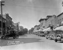
| Date: | 1926 |
|---|---|
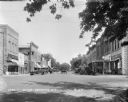
| Description: | View down the brick street in a busy commercial area. Cars are parked on either side of the road. |
| Date: | 1926 |
|---|---|
| Description: | View down a cobblestone brick road. Stores on the street include: the Columbus Hotel, Tremont Hotel, and a drug store. |

| Date: | 1967 |
|---|---|
| Description: | A group of young migrant farm laborers leaving a cucumber field in a Chevy station wagon for a union rally in Portage. Three children are looking at the ca... |

| Date: | 1905 |
|---|---|
| Description: | Shows railroads, roads, post offices, creeks, lakes, and cities. Includes chart of deposits and total resources from the years 1890 to 1905. "First Natio... |

| Date: | 1877 |
|---|---|
| Description: | Shows land ownership by name, churches, schools, farm houses, wagon roads, railroads. Includes directory of businesses for Columbus, Portage, Doylestown, W... |
| Date: | 1929 |
|---|---|
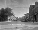
| Description: | View down street at intersection of commercial buildings on both sides. On the left is a drug store/soda fountain, restaurant and a cafe. On the right is a... |

| Date: | 11 21 1950 |
|---|---|
| Description: | This map shows agricultural, residence, business, and industrial districts as well as lot and block numbers. |
| Date: | 1891 |
|---|---|
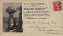
| Description: | H.H. Bennett advertising envelope addressed to William H. Metcalf of Milwaukee. The envelope bears an engraved image of people standing on top of Stand Roc... |

| Date: | 1914 |
|---|---|
| Description: | This photostat map shows Fort Winnebago around 1931, land to be reserved for military purposes, roads to Fort Howard and Fort Crawford, "private property" ... |

| Date: | 1900 |
|---|---|
| Description: | This map shows landownership, churches, schools, farm houses, wagon roads, railroads, and townships and includes businesses advertisements, tables of stati... |
If you didn't find the material you searched for, our Library Reference Staff can help.
Call our reference desk at 608-264-6535 or email us at: