 Filter: Categories of Wisconsin Historical Images
Filter: Subject of Dwellings
Filter: Subject of wetlands
Filter: Categories of Wisconsin Historical Images
Filter: Subject of Dwellings
Filter: Subject of wetlands

| Date: | 1882 |
|---|---|
| Description: | This manuscript map from 1882 shows land use and land for sale in a portion of the Town of Pewaukee, Waukesha County, Wisconsin. Woods, marshland, springs,... |

| Date: | 1888 |
|---|---|
| Description: | This late 19th century map of Price County, Wisconsin, shows landownership and waterfront acreages, the township and range system, towns, cities and villag... |

| Date: | 1902 |
|---|---|
| Description: | This 1902 map of the eastern portion of Sawyer County, Wisconsin, shows the township and range system, sections, roads, farm houses, camps, school houses, ... |

| Date: | 1919 |
|---|---|
| Description: | This 1919 map of Sawyer County, Wisconsin, shows the township and range system, sections, cities and villages, roads, railroads, farm houses, the Indian re... |

| Date: | 1871 |
|---|---|
| Description: | This map of Barron County, Wisconsin, shows the township and range grid, towns, sections, cities and villages, post offices, dwellings, schools, roads, swa... |

| Date: | 1882 |
|---|---|
| Description: | This 1882 map of Barron County, Wisconsin, shows the township and range grid, towns, cities and villages, wagon roads, railroads, schools, dwellings, and l... |

| Date: | 1836 |
|---|---|
| Description: | This map shows settlers houses and businesses, trails, and swamps. The relief is shown by hachures. The map includes illustrations of historical buildings ... |

| Date: | 1929 |
|---|---|
| Description: | Elevated view from Signal Point of the Mississippi River, railroad and surrounding forest and wetlands. |

| Date: | 1780 |
|---|---|
| Description: | This map shows the townships, parishes, cities, towns, plantations, lakes, rivers, swamps, and roads near the coast of South Carolina and Georgia. Emphasis... |
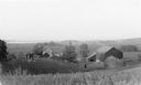
| Date: | 1935 |
|---|---|
| Description: | Elevated view from hill of chickens ranging near their coop behind a farmhouse and outbuildings on a tidy farm. There is a large barn on the right with two... |

| Date: | 1975 |
|---|---|
| Description: | View through snow-covered cattails after a winter snowfall towards a house on the left, and a barn and a silo on the right. |
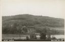
| Date: | 1907 |
|---|---|
| Description: | Text on front reads: "Mount Morris. Wautoma, Wis." A view of Mount Morris from above the shore of a lake or pond. A dwelling and perhaps a farm can be seen... |
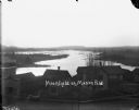
| Date: | 1900 |
|---|---|
| Description: | Elevated view over the tops of buildings to the water beyond. A wooden sidewalk and fence runs along the street in the foreground. Caption on negative read... |
If you didn't find the material you searched for, our Library Reference Staff can help.
Call our reference desk at 608-264-6535 or email us at: