 Filter: Categories of Wisconsin Historical Images
Filter: Subject of Drawing
Filter: Year of 1800-1899
Filter: Year of 1830-1839
Filter: Categories of Wisconsin Historical Images
Filter: Subject of Drawing
Filter: Year of 1800-1899
Filter: Year of 1830-1839
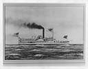
| Date: | 1832 |
|---|---|
| Description: | An early type of sidewheel passenger and freight steamboat The Milwaukie, also known as The Milwaukee. It was used on Lake Erie and upper lak... |
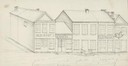
| Date: | 1838 |
|---|---|
| Description: | Pencil sketch of a building owned by the Rodolf family along a commercial street. |
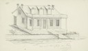
| Date: | 1838 |
|---|---|
| Description: | Pencil sketch of a stone house with a porch the full length of the dwelling, supported by 6 columns. |
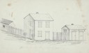
| Date: | 1838 |
|---|---|
| Description: | Pencil sketch of buildings, including the Post Office. |

| Date: | 1833 |
|---|---|
| Description: | Drawing on a faint grid with Lake Michigan on the right, and the rivers on the left. Labeled is an Indian Village, J. Veiu, S. Juneau, and P. Juneau. Alo... |

| Date: | 1836 |
|---|---|
| Description: | This map shows lot and block numbers, streets, a proposed canal basin, Fort Winnebago, and the Wisconsin and Fox Rivers. Relief is shown by hachures and no... |
If you didn't find the material you searched for, our Library Reference Staff can help.
Call our reference desk at 608-264-6535 or email us at: