 Filter: Categories of Wisconsin Historical Images
Filter: Subject of Deer
Filter: Subject of water
Filter: Categories of Wisconsin Historical Images
Filter: Subject of Deer
Filter: Subject of water

| Date: | 1832 |
|---|---|
| Description: | Junction of the Yellowstone River and the Missouri River. |

| Date: | 1854 |
|---|---|
| Description: | Drawing of the Porcupine Mountains on Lake Superior. A deer is standing in the lake drinking water. A man is on the rock ledge above the shoreline and is a... |
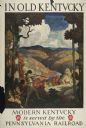
| Date: | 1930 |
|---|---|
| Description: | An original lithograph promoting Kentucky and the Pennsylvania Railroad through an artist's depiction of two men dressed in buckskin, wearing raccoon hats ... |

| Date: | |
|---|---|
| Description: | Wisconsin promotional decal with a map of the state, with many cities marked and drawings of some Wisconsin icons: cheese, cows, deer, beer, Wisconsin Dell... |

| Date: | 1935 |
|---|---|
| Description: | Log cabins on forested shoreline of Namakagon Lake. A young deer is standing in front of wooden rowboats on the shoreline. |
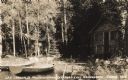
| Date: | 1934 |
|---|---|
| Description: | View from water towards shoreline of two boats at Les Crandall's Housekeeping Cottages on Lake Namakagon tied up in front of two log cabins. A deer (not kn... |
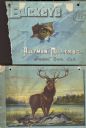
| Date: | 1889 |
|---|---|
| Description: | Front and back cover of catalog for harvesting machines. Front contains illustration of a torn hole with the eye of a buck looking through the hole. Superi... |

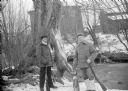
| Date: | 1910 |
|---|---|
| Description: | Two hunters pose in a wooded area. Their kill, two deer, hang upside down from a wooden beam supported by branches of trees. The deer have what appear to b... |
| Date: | |
|---|---|
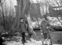
| Description: | Exterior portrait of two hunters posing with a deer carcass, a fox carcass and rifles on the edge of a stream in winter. Buildings are in the background. |
| Date: | |
|---|---|
| Description: | Outdoor portrait of two hunters posing with a deer carcass, a fox carcass and rifles on the edge of a stream in winter with snow on the ground. Building ar... |

| Date: | |
|---|---|
| Description: | Cigar box cover with a head and shoulders portrait of Nelson Dewey. Beneath his portrait is a Native American headdress, a tomahawk, a stone club and a qui... |

| Date: | 1952 |
|---|---|
| Description: | This map shows lakes, rivers, railroads, highways, roads, hunting grounds and trails around Flambeau Flowage and Boulder Junction in the north, to Brantwoo... |

| Date: | 1966 |
|---|---|
| Description: | This map shows trails, roads, creeks, alleged location of George Gardner's trading post, Boulder and Mud Lakes, and a portion of the Wolf River. The map al... |

| Date: | 1718 |
|---|---|
| Description: | This map shows the Mississippi River, with latitude and longitude coordinates, ad covers east to Lake Ontario and south to Illinois. The inset map (the top... |
| Date: | 1851 |
|---|---|
| Description: | Pictograph E., Plate 63, "Kaizheosh, and his Band from Lake Vieu Desert. Michigan and Wisconsin." A group of symbols including birds, animals, a fish and a... |

| Date: | 1746 |
|---|---|
| Description: | This world map from the German mathematician, historian, and geographer Johann Matthias Hase shows the major cities, islands, and the major political divis... |

| Date: | 1636 |
|---|---|
| Description: | Map of North America, divided into regions, and showing some rivers, lakes, settlements, cities, mountains, and Native American land. Of the Great Lakes on... |

| Date: | 1740 |
|---|---|
| Description: | Map including the regions and cities of the northern half of North America. Native American land, rivers, lakes, mountains are labeled. Mountains, marshes,... |

| Date: | 1759 |
|---|---|
| Description: | Map of north eastern Canada and parts of New England, showing settlements, cities, portages, Native American land, mountains, lakes, and rivers. The unusua... |

| Date: | 11 1963 |
|---|---|
| Description: | In the woods, a man is cooking over a campfire, while a deer carcass is hanging from the branch of a tree. Sid's poem accompanying the image in the newspap... |
If you didn't find the material you searched for, our Library Reference Staff can help.
Call our reference desk at 608-264-6535 or email us at: