 Filter: Categories of Wisconsin Historical Images
Filter: Subject of Deer
Filter: Subject of rivers
Filter: Categories of Wisconsin Historical Images
Filter: Subject of Deer
Filter: Subject of rivers

| Date: | 1832 |
|---|---|
| Description: | Junction of the Yellowstone River and the Missouri River. |
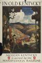
| Date: | 1930 |
|---|---|
| Description: | An original lithograph promoting Kentucky and the Pennsylvania Railroad through an artist's depiction of two men dressed in buckskin, wearing raccoon hats ... |

| Date: | |
|---|---|
| Description: | Wisconsin promotional decal with a map of the state, with many cities marked and drawings of some Wisconsin icons: cheese, cows, deer, beer, Wisconsin Dell... |

| Date: | 1910 |
|---|---|
| Description: | Two hunters pose in a wooded area. Their kill, two deer, hang upside down from a wooden beam supported by branches of trees. The deer have what appear to b... |

| Date: | 1952 |
|---|---|
| Description: | This map shows lakes, rivers, railroads, highways, roads, hunting grounds and trails around Flambeau Flowage and Boulder Junction in the north, to Brantwoo... |

| Date: | 1966 |
|---|---|
| Description: | This map shows trails, roads, creeks, alleged location of George Gardner's trading post, Boulder and Mud Lakes, and a portion of the Wolf River. The map al... |

| Date: | 1636 |
|---|---|
| Description: | Map of North America, divided into regions, and showing some rivers, lakes, settlements, cities, mountains, and Native American land. Of the Great Lakes on... |

| Date: | 1740 |
|---|---|
| Description: | Map including the regions and cities of the northern half of North America. Native American land, rivers, lakes, mountains are labeled. Mountains, marshes,... |

| Date: | 1759 |
|---|---|
| Description: | Map of north eastern Canada and parts of New England, showing settlements, cities, portages, Native American land, mountains, lakes, and rivers. The unusua... |

| Date: | 1935 |
|---|---|
| Description: | A flash photograph of a large whitetail buck standing in shallow water of the Brule River. |
If you didn't find the material you searched for, our Library Reference Staff can help.
Call our reference desk at 608-264-6535 or email us at: