 Filter: Categories of Wisconsin Historical Images
Filter: Subject of Deer
Filter: Subject of cities and towns
Filter: Categories of Wisconsin Historical Images
Filter: Subject of Deer
Filter: Subject of cities and towns
| Date: | 11 27 1934 |
|---|---|
| Description: | A 14-point buck shot by Carl Laughnan, 4138 Mandan Crescent, and a 10-point buck shot by Russell Hegg, 330 Dow Court, are tied to the front fenders of the ... |
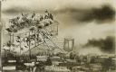
| Date: | 1909 |
|---|---|
| Description: | Photomontage of Santa Claus and his reindeer riding on the top wing of a bi-plane. More sacks of toys and wrapped gifts are on the lower wing. Buildings an... |
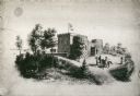
| Date: | 1870 |
|---|---|
| Description: | Benjamin Walker Castle, 1862-1893, 900 block East Gorham Street. There are two deer are the left near trees, and two people are on horseback near the front... |

| Date: | 1910 |
|---|---|
| Description: | Hunters dragging deer from woods. In the center is Frank Langeois, son of Joseph Jr. |

| Date: | 12 20 1948 |
|---|---|
| Description: | White and dark European fallow, and a Sika Nippon deer, at the Vilas Park Zoo (Henry Vilas Zoo) in Madison. |

| Date: | 1910 |
|---|---|
| Description: | Bringing in two small bucks, dead and loaded on a sled behind a team of horses, Old Camp 2. The third man from the right is Clarence Deitz. |
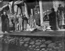
| Date: | 1900 |
|---|---|
| Description: | A group of men stand in front of the Schwaller building on Pine Street with two male deer carcasses on the board sidewalk. The man touching the antlers is... |

| Date: | |
|---|---|
| Description: | Wisconsin promotional decal with a map of the state, with many cities marked and drawings of some Wisconsin icons: cheese, cows, deer, beer, Wisconsin Dell... |
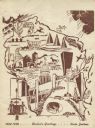
| Date: | 1948 |
|---|---|
| Description: | Holiday card of the history of the State of Wisconsin, 1848-1948. Shows a map of Wisconsin with many historical and themed elements. Image was created by w... |
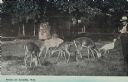
| Date: | |
|---|---|
| Description: | A man is watching deer eating grass. There is also a turkey on the right. Caption reads: "Scene at Arcadia, Wis." |
| Date: | 1910 |
|---|---|
| Description: | The hunters, holding their guns, are wearing long coats and hats. They are standing on a sidewalk, and the deer are strung up in trees. A small child is st... |

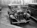
| Date: | 11 1959 |
|---|---|
| Description: | Danny Sands and Dick Goldfield (right) standing by a wood-sided station wagon with two deer tied to the front hood lid, and a third deer on top of the car.... |

| Date: | |
|---|---|
| Description: | Group portrait of a dozen men posing sitting and kneeling while holding rifles in front of thirteen deer strung up across First Street. They are in front o... |

| Date: | |
|---|---|
| Description: | Nine men posing while holding rifles in front of twelve deer strung up across First Street in front of the brick building that held Charles J. Van Schaick'... |

| Date: | 1908 |
|---|---|
| Description: | Copy photograph of an outdoor portrait of a group of men standing and kneeling in front of a line of deer suspended across First Street in Black River Fall... |
| Date: | |
|---|---|
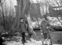
| Description: | Exterior portrait of two hunters posing with a deer carcass, a fox carcass and rifles on the edge of a stream in winter. Buildings are in the background. |
| Date: | |
|---|---|
| Description: | Outdoor portrait of two hunters posing with a deer carcass, a fox carcass and rifles on the edge of a stream in winter with snow on the ground. Building ar... |

| Date: | 1718 |
|---|---|
| Description: | This map shows the Mississippi River, with latitude and longitude coordinates, ad covers east to Lake Ontario and south to Illinois. The inset map (the top... |

| Date: | 1746 |
|---|---|
| Description: | This world map from the German mathematician, historian, and geographer Johann Matthias Hase shows the major cities, islands, and the major political divis... |

| Date: | 1636 |
|---|---|
| Description: | Map of North America, divided into regions, and showing some rivers, lakes, settlements, cities, mountains, and Native American land. Of the Great Lakes on... |
If you didn't find the material you searched for, our Library Reference Staff can help.
Call our reference desk at 608-264-6535 or email us at: