 Filter: Categories of Wisconsin Historical Images
Filter: Subject of Dams
Filter: Categories of Wisconsin Historical Images
Filter: Subject of Dams

| Date: | 1907 |
|---|---|
| Description: | Topographic map of the Wisconsin River done under direction of Daniel Meade for construction of the Kilbourn dam by the Southern Wisconsin Power Company. I... |

| Date: | 1926 |
|---|---|
| Description: | This hand-colored blueprint map shows landowners in part of T15N, R5E in Juneau County. North is oriented to the right. |
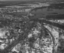
| Date: | 04 16 1949 |
|---|---|
| Description: | Aerial view of Necedah, Wisconsin, and Petenwell Lake behind Petenwell Dam on the Wisconsin River. |
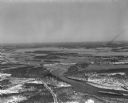
| Date: | 04 16 1949 |
|---|---|
| Description: | Aerial view of Castle Rock Dam on the Wisconsin River near Mauston, Wisconsin. |
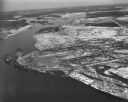
| Date: | 04 16 1949 |
|---|---|
| Description: | Aerial view of Petenwell Dam and dike on Wisconsin River twenty miles north of Necedah, Wisconsin showing the early formation of Lake Petenwell. |
| Date: | 05 06 1894 |
|---|---|
| Description: | Monongahela River view of a dam at Lock #2. |
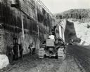
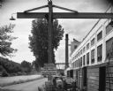
| Date: | 10 04 1946 |
|---|---|
| Description: | Men work with an International TracTracTor (crawler tractor) in construction of the Merriman Dam. The tractor was owned by S.A. Healy Co., White Plains, Ne... |
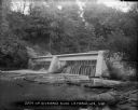
| Date: | 1904 |
|---|---|
| Description: | A view looking west over water toward the Fox River dam at Montello. There is granite riprap on the left. A boat with a small sail is in the background. T... |
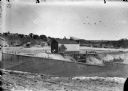
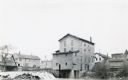
| Date: | |
|---|---|
| Description: | Men working around a small building near the construction site of a dam. Two men are standing on the roof. Houses and other buildings are on a hill in the ... |
| Date: | 1932 |
|---|---|
| Description: | Exterior view of Taliesin and its hydroelectric plant. Caption on photograph reads, "Dam at Frank Lloyd Wright's Bungalow-Taliesin-near Spring Green, Wis."... |

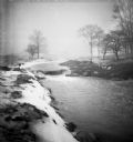
| Date: | |
|---|---|
| Description: | Wolf River Dam with ice and snow. Houses are in the background. |

| Date: | |
|---|---|
| Description: | "Peavy Falls Group" of men and boys posed on bank of river. There is a man in a canoe in the river, and a footbridge in the background. |
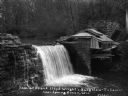
| Date: | |
|---|---|
| Description: | View from shoreline of dam on Kickapoo River. There is a steep hill on the left, and both sides of riverbank are covered with trees. |
| Date: | |
|---|---|
| Description: | The Root River swollen with rainwater and/or snow melt. A recently built duplex housing unit is visible in the background. This picture was likely taken as... |
| Date: | |
|---|---|
| Description: | The Root River swollen with rainwater and/or snow melt. This picture was likely taken as a study of the water drainage in early Greendale. |
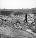
| Date: | |
|---|---|
| Description: | A man stands on rocks that will dam Dale Creek. This picture was likely taken for a study of the water drainage system in early Greendale. |
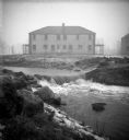
| Date: | 08 05 1962 |
|---|---|
| Description: | Exterior view of Riverside Paper Corporation mill. On the left is a road along a river, and on the right are railroad tracks along the mill. A sign in the ... |
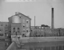
| Date: | 1924 |
|---|---|
| Description: | The dam and four-story wooden mill on the Baraboo River. A bridge crosses the river on the left. There are houses and commercial buildings in the backgrou... |

| Date: | 1918 |
|---|---|
| Description: | A dam and small mill building on the Willow River. The plant, built by Christian Burkhardt as part of the Burkhardt Milling and Electric Power Company, ope... |
| Date: | 09 19 1961 |
|---|---|
| Description: | View of a woolen mill, as seen from across a river and dam. |
If you didn't find the material you searched for, our Library Reference Staff can help.
Call our reference desk at 608-264-6535 or email us at: